Toponyms is a general scholarly study of place names as they have been established and disputed over time by different cultural groups and nation states. Culturally based place names can reference small geosites, long ceremonial landscapes based on established trails, and massive geoscapes that are functionally integrated by geology, climate, and human use. Many of these geosites have been celebrated by nations in recent times as national parks and world heritage sites. Multivocality is a term used by the USA federal government to reflect multiple names for places by cultural groups. Sunset Crater in Arizona after ethnographic studies [1] involving multiple Native groups who are now recognizes in a trail sign containing authentic traditional toponyms reflecting ancient connections with this volcano (Figure 1). Surrounding the park are volcanic lands (Figure 2). The park continues to be referred to by its colonial name Sunset Crater and the surrounding lands are called the Flagstaff Volcanic Landscape.
A geosite is best understood in terms of its surrounding topography (geoscape). A new trail sigh provides a map of eight Native toponyms (Figure 2). Only one mountain toponym is allocated to each tribe or pueblo although all peaks in this area have their own Native names and stories. Note the Native toponyms map is imbedded in a larger colonial toponym interpretation where the peaks are named after one Spanish and three English colonial explorers, and the area is called by the Spanish colonial name, the San Franciso Mountains. Figure 2B illustrates the complexity of modern toponym renaming and the resulting multivocality.
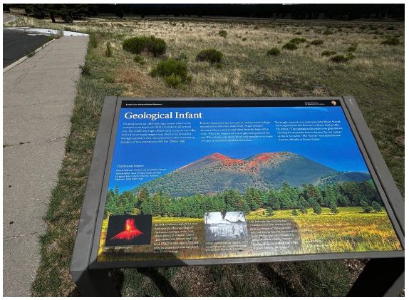
Figure 1: The multivocality of cultural place names on a trail sign at Sunset Crater National Monument in Arizona (soured Van Vlack 2025) [2].
As they increasingly become more formally defined and celebrated, debates over place names and their meanings have increased, which, now have been more specifically defined by Toponymic Guidelines of the United Nation which have been negotiated by a series of formal committees (United Nations Group of Experts on Geographical Names2018) [3]. The content of Toponymic Guidelines has been developed since 1979 and includes information about official, national and minority languages, names authorities, source material for toponyms, glossaries, abbreviations used on official maps, differentiating text from toponyms on national maps, and administrative regions. At the Ninth Conference (United Nations 2007) [4], it was acknowledged that the format should not be too restrictive; also considered important were having guidelines in more than one language and cooperating with neighboring countries. A toponymic landscape involves the functional interconnections of geosites and geotrails to form a geoscape. The naming of new places during colonial expansion is well documented. For example, in Australia, studies analyze the effects of British settler colonialism on the toponymic landscape of lands traditionally cared for by Indigenous Australian peoples [5]. So, in the Australian research and analysis as of contemporary national efforts to rectify these past colonial changes. Detailed toponymic research has focused on lands where Germans were the first settler colonialists to alienate land in portions of southern Australia, thus dispossessing the Nunga as traditional owners. The encroaching German settlers created a toponymic landscape that reflected their culture and history and the geological characterizes of the new lands where they settled. The German toponymic landscape of settled places was derived from religious sources, from a person’s name, and from the name of their home communities in German.
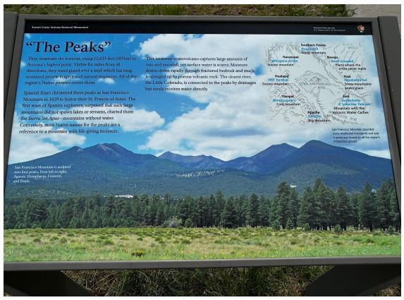
Figure 2: A Park Trail Sign Identify Nearby Native Toponyms of Volcanic Mountains (Source Van Vlack 2025) [2].
The Cases
This brief, case-based review essay reflects findings from five of our ethnographic studies that have involved Native Americans. Each case illustrated contemporary Toponyms issues involving Native people and Colonial Settlers in North America and disputes over the names of places. Each of these case studies represent but a small segment of a much broader international issue that was largely crated by worldwide human events in the Pre-colonial, Colonial, Post-colonial, and Neocolonial periods which have occurred over the past 500 years. All these cases of Toponym disputes have occurred or are occurring between the Native and Colonial peoples. The cases involve Geosites, Geotrails, and Geoscapes. Findings from all cases are available publicly.
Geosite- Mato Tepe or Devils Tower, Wyoming
Mateo Tepe (Figure 3) is a Native name for a shared sacred geosite composed earth and fire materials. Debate of toponyms is whether it should be the stairs to Heaven as the 23 Native tribes maintain or the steps to Hell as the Devils Tower implies (Stoffie et al 2024). This place name debate immediately when it was mapped by exploring expedition of the USA colonial state and continues to today. Mateo Tepe has been placed on the list of the most important geosites in the World and was nominated as both a geology place and a cultural place [6]. Using both Toponyms, this geosite was awarded a position on the official lists of significant International Commission on Geoheritage Sites.
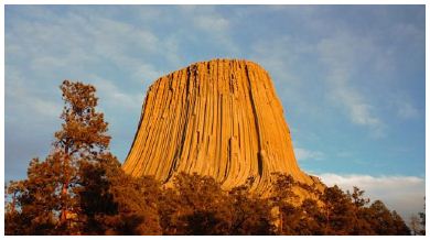
Figure 3: Mateo Tepe Stairs to Heaven or Steps to Hell?
Devils Tower was declared as the first National Monument because of its geological value, but it is now recognized for its value for Native Americans.
Geotrail – Old Spanish Trail: Native Communities, USA Southwest
The Old Spanish Trail (OST) has been designated as a National Historic Trail by the NSP. An ethnographic study [7] involving Native tribes who traditionally lived along the trail study was funded and thus were impacted by the thousands of animals and people who traveled in large caravans along it from New Mexico to California. All participating tribes disputed the US applied name for the trail which they maintained was a series of traditional Native trails linked for the caravans. The Taos Pueblo was so incensed by the name that they refused to participate in the study even though the events along the OST were key in their history.
Geoscape – Bears Ears, Utah
Presently 32 tribes have expressed cultural connections to Bears Ears (Figure 4) as a geosite and its surrounding geoscape. Each tribe has a name for this place in their own language and their own stories about why it is important. The Hopi refer to it as Hoon’Naqvut, the Navajo call it Shash Jaa,’ the Utes named it Kwiyagatu Nukavachi, and for Zuni it is Ansh An Lashokdiwe. During an ethnographic study that involved nine culturally affiliated tribes, tribal representatives shared their deep time but different kinds of cultural attachments to this geosite and geoscape [2].
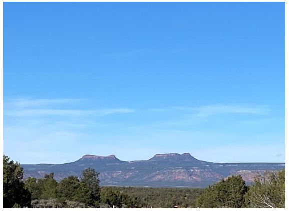
Figure 4: Bears Ears is a culturally significant geoscape in southeast Utah.
Geoscape – Iliamna Lake (Nanvarpak, Nila Vena) Native and Local Place Names Alaska)
This is an extended ethnographic and linguistic study of a Native toponyms associated with large lake (Figure 5) (a geosite) and the numerous geosites that constitute its massive integrated surrounding geoscape [8-10]. The research illustrates how difficult it is to both explain and share toponymic information across linguistic and cultural differences. The researcher devoted years to accomplishing this goal which had epistemological, cultural protocols, and privacy challenges.
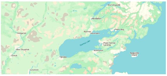
Figure 5: Iliamna Lake, Biggest Lake in Alaska.
Geoscape – El Malpais National Monument, New Mexico
El Malpais National Monument is an ancient area consisting of two unique geoscapes– lava flows occurring on top of each other forming layers of volcanic fields (Figure 6) and underground lava tunnels (Figure 7). It occurs at the foot of a massive sacred mountain with the colonial name Mount Taylor. The mountain and lava field are active ceremonial areas and considered living due to the rebirth of the Earth.
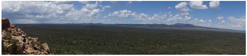
Figure 6: Volcanic Fields of El Malpais National Monument.
Today the lava flows are managed as a park by the US NPS using the area’s original colonial toponym. El Malpais is a Spanish term for a bad place or bad lands but the many tribes and pueblos who participated in the NPS funded ethnographic study of this lava flow park define it using their own linguistic terms and traditional uses patterns that its cultural importance and spiritual value [11].
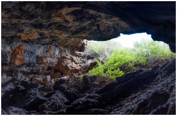
Figure 7: One of Many Lava Tunnels in the Monument.
Toponyms Discussion
Many geosite toponym disputes are between Native people whose lands are involved in encroachment of members of the conquering colonial society. Native people today, however, often experience conflict with each other regarding appropriate place terms. This is a situation debate that derives from the western views of property and ownership of places. A finding from our ethnographic studies is that places are culturally layered with different meaning specific to the peoples who have interrelated with each other and the geosite for long periods. For Native people of the Southwest US this is now documented to be about 40,000 years. Deep time and multicultural connections make for complex understandings of places, as our studies have shown. This complexity becomes a key issue when Native people participate as tribal representatives at land management meetings where their desire to apply or preference traditional toponyms face resistant from supporters of colonial toponym meanings.
References
- Stoffie, Richard, and Kathleen Van Vlack (2022) Talking with a Volcano: Native American Perspectives on the Eruption of Sunset Crater, Arizona. Land 11.
- Van Vlack Kathleen, H Lim, J Yaquinto, J Gazing Wolf, B Eguino-Uribe, et (2025) Monticello BLM Ethnographic Partnership: An Ethnographic Overview and Assessment of the Cedar Mesa and Bears Ears Region. Heritage Lands Collective: Cortez, CO.
- United Nations Group of Experts on Geographic Names (2018) Toponymic Guidelines for Map and Other Editors for International Use.
- United Nations (2007) Ninth United Nations Conference on the Standardization of Geographical New York. United Nations.
- Spennemann DHR (2025) A Disappearing Cultural Landscape: The Heritage of German-Style Land Use and Pug-And-Pine Architecture in Land. 14.
- Stoffie R, K Van Vlack V, Semeniuk, M Brocx (2025) Devils Tower, Mateo The Second 100 IUGS Geological Heritage Site. The Second 100 IUGS Geological Heritage Site.
- Stoffie R, K Van Vlack R, Toupal S, O’Meara, R Arnold (2008) American Indians and the Old Spanish Tucson, AZ: Bureau of Applied Research in Anthropology, University of Arizona.
- Kugo Y (2020) Artic Data: Iliamna Lake (Nanvarpak, Nila Vena) Native and Local Place Names (2016-2019).
- Kugo Y (2021) Documenting Yup’ik Place Names with Yoko Kugo. Artic Data Center Blog.
- Kugo Y( ed) (2024) Nanvarpagmiut Qanemciit-llu/ Iliamna Lake People and Their Stories: Place Names and Sense of Fairbanks, AK: Alaska Native Language Center, University of Alaska.
- Larsson Simon (2025) The Connectedness of People and Geological Features in the El Malpais Lava Flows of New Mexico, USA. Land 14.