Abstract
Glaciological studies have been conducted on several snow patches in Japan since 1910th,, including a recent report with the conclusion that some perennial snow patches in the Hida Mountains in north-central Japan are identified as glaciers. The identification was supported by all Japanese glaciologists at an open symposium organized by the Data Center for Glacier Research of the Japanese Society of Snow and Ice, recognizing that the snow patches have considerable amount of ice mass in the lower part of the snow patch, which shows the evidence of flow downwards along the valley. The international cryosphere-related organizations, however define the glacier as “stagnant or flowing ice mass”, and the international classification of glaciers published by the International Commission of Snow and Ice (ICSI) shows the necessity of flow only for some classes of glaciers such as the valley glacier, outlet glacier etc., and thus, the flowing is found not principally necessary to identify some groups of glaciers. Examining comparatively the pilot study in the Himalayan region given by the ICSI, several snow patches with ice masses in Japan are considered to belong the valley glacier, mountain glacier, or glacieret. However, the ICSI classification above includes vagueness on flow, size and thickness of the ice mass, distinction among valley glacier, mountain glacier, glacieret and snow patch. Those points should be examined and clarified for the better definition and classification of snow and ice masses on the earth.
Introduction
There is a variety of snow and ice masses on the globe. Some of them have been regarded as the glacier. However, the definition and classification of the glacier is not clearly understood even in researchers of related sciences. In Figures 1-3 some typical glaciers, which should be understood generally as the valley glacier, mountain glacier, and ice sheet with an outlet glacier are given.
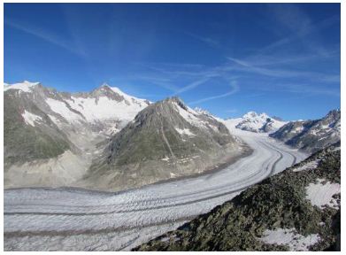
Figure 1: Aretsch Glacier in the Swiss Alps, view of the middle reaches. Far above, uppermost cirques are seen (Photo provided by R. Naruse, taken in July 2018).
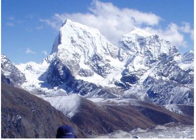
Figure 2: West side view of Arakam tse, Everest area, with typical mountain glaciers on the west slope. A small valley glacier is seen on southeast of the peak and a large Nojumba Glacier is seen on the bottom of the picture. (Photo taken in October 2007).
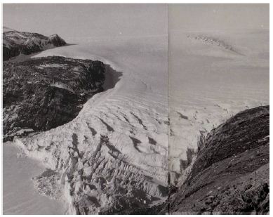
Figure 3: Antarctic ice sheet in eastern Queen Maud Land and Skallen outlet glacier, February. 1970
In 2012, 3 perennial snow patches in Tateyama-Tsurugi range of Hida Mountains in north-central Japan were identified as active glaciers by Fukui and Iida (2012) [1]. About one hundred glaciologists in Japan assembled and discussed on the report at an open symposium [Perennial snow patches and glaciers in Japan – past studies and future researches organized by the Data Center for Glacier Research of the Japanese Society of Snow and Ice (JSSI) [2]. The summary of the symposium is that the participants of the symposium do not object to call these 3 snow patches as the glacier.
The present author has had some experiences of observing glaciers worldwide as a geologist and a mountaineer since the 1960s, and has been interested in the active glaciers reported by Fukui and Iida. It is found that there are some vagueness to be clarified on the definition and classification of glaciers. The present author proposed in 2019 (Yoshida, 2019-2020) [3,4] to call the above kind of snow patches as the “snow patch glacier” (abbreviated as SPG from here onwards in this paper). Recent researches in Japan on SPGs are considered useful to contribute the understanding of similar SPGs, which are distributed widely in some areas of the earth.
Glaciological Research on Perennial Snow Patches in Japan
The beginning of glaciological studies on perennial snow patches in Japan was the report by Ohzeki (1917) [5] on a perennial snow patch (designated as PSP below onwards) in Mt. Gassan in Northeast Japan. Ohzeki showed the shape, structure, and size of the ice mass within a large perennial snow patch known as “Ohyukijiro” (big snow castle, in Japanese meaning), and pointed out a possibility that the snow patch is similar with the glacieret distributed at several places in European Alps.
Since then several glaciological studies on snow patches in Japan including the report of identification of glaciers or glacierets were conducted [1,6-31] in mountains in Hokkaido, Northeast Japan and north central Japan, etc.
After around 1970, a systematic study project of snow patches in Japan started led by Prof. K. Higuchi of Nagoya University. The study project was related with the International Hydrological Decade (IHD, 1963-1974) and Intergovernmental Hydrological Programme (IHP, 1975-) that aimed to clarify the actual situation of water resources and to contribute to the examination of their relationship with climatic changes. Due to the studies of the above Japanese project, the outline of perennial snow patches distributed throughout Japan was clarified and detailed studies of several snow patches were also conducted. All these studies contributed to the IHD-IHP projects for the formation of the world glacier inventory.
The glaciological researches in Japan had been influenced by the general idea of Japanese geomorphologists that there should be no glaciers in Japan referring the suggestion of Hoshiai and Kobayashi (1957) [32] that the equilibrium line altitude (snow line) in Japan is 4000 meters, which is nearly one thousand meters higher than the Japanese highest mountain range. Several glaciological researches in Japan, however, have been conducted even after 1957. It is first because field evidence of glaciologic characteristics of some snow patches were noticed, and second because the idea that the snow line might change locally due to differences in local climate and topography, which affect in large differences in the amount of snow accumulation and melting. The above idea was further clearly pointed out recently by Ono [33].
In 2012, Fukui and Iida [1] reported 3 PSPs in Tateyama-Tsurugi range in the Hida Mountains (Japanese North Alps) in north-central Japan are identified as active glaciers. These PSPs are several hundred to over one km in length, have a thick (25 – 45 meters thick) ice bodies in the lower horizons, and are flowing downwards some meters per year. They showed mesoscopic and microscopic inner structure of the ice mass and figured out the mechanism of ductile flow of the mass. Fukui and Iida (2012) [1] pointed out that the above signatures are conformable with the definition of glaciers.
An open symposium [Perennial snow patches and glaciers in Japan- past studies and future researches] was held in 2012 at the Data Center for Glacier Research of JSSI to discuss on the report of Fukui and Iida (2012) [1], and about 100 members of the society assembled.
During the symposium, several lectures and discussions were presented in relation to the report of Fukui and Iida (2012) [1]. At the end of the symposium, the chairman summarized that all the participants did not deny that 3 PSPs reported by Fukui and Iida could be called as the glacier, but one PSP has to be further examined, because the flow of the PSP is not clear [34]. In the symposium, however, there appeared to have been no discussion on the criteria of definition and classification of glaciers, and further, no discussion referring those by international organizations such as the International Glaciological Society (IGS), ICSI, etc. Almost all participants of the symposium appeared to have had the understanding on the definition of glaciers as that given in the so far published dictionaries of JSSI [35].
Fukui and others [29] and Arie and others (2019) [30] further reported additional 4 PSPs in the Hida Mountains with the conclusion that they also have signatures to be identified as glaciers. Similar PSPs in the Hida Mountains are under the survey by the same authors and will shortly be reported. The distribution of these snow patches are shown on topographic maps in Figures 4-6. In these maps, all large snow patches shown on the 1:25000 topographic map of the Geospacial Information Authority of Japan (2018) [36] are delineated by the present author. Snow patches, which were so far reported [1,29-31] that they have or should have an ice mass are shown as SPG. Field photos of some of the above SPGs are given in Figures 7-9. A detailed topographic sketch and a cross section of one of the SPGs are shown in Figure 10a and 10b, citing after Fukui et al. [29].
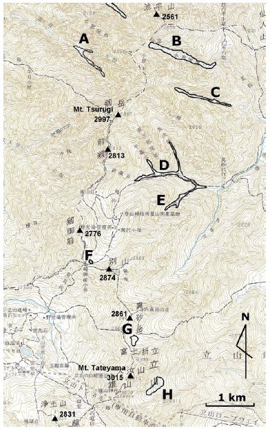
Figure 4: Distribution of SPGs and a PSP surrounding Mt. Tateyama in the northwestern Hida Mountains. A: Ikenotani SPG, B: Komado SPG, C: San-no-mado SPG, D: Tsurugisawa PSP, E: Bessanzawa PSP, F: Hamaguriyuki SPG, G: Kuranosukesawa SPG, H: Gozensawa SPG.
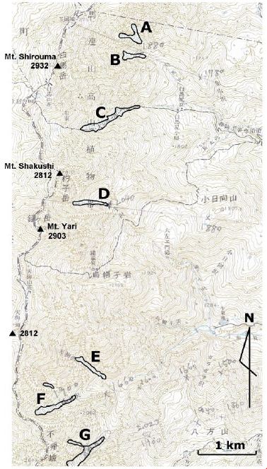
Figure 5: Distribution of SPGs and PSPs on the eastern slope of Mts.Shiroumadake-Karamatsudake in theNortheastern Hida Mountains. A: Hakubasawa migimata PSP, B: Hakubasawa SPG, C: Daisekkei PSP, D: Shakushizawa SPG, E: Tengusawa PSP, F: Kaerazusawa SPG, G: Karamatsuzawa SPG.
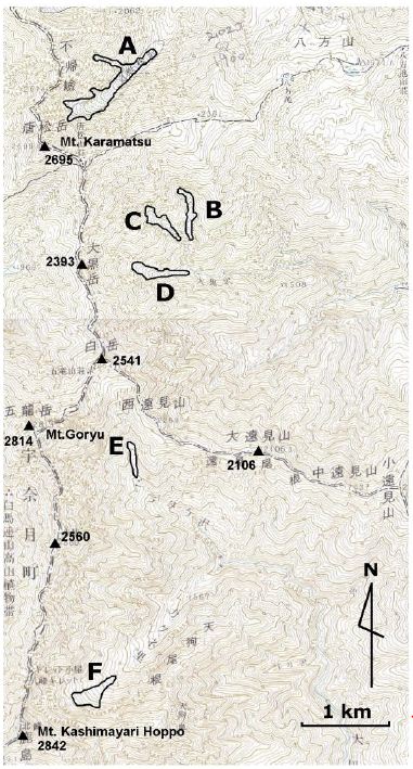
Figure 6: Distribution of SPGs and PSPs in eastern slopes of Mts.Karamatsudake-Kashimayarigatake, northeastern Hida Mountains.A: Karamatsuzawa SPG, B: Ohgurozawa-migimatamigi PSP, C.
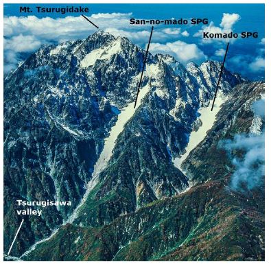
Figure 7: San-no-mado SPG and Komado SPG on the eastern slope of Mt. Tsurugidake (Aerial Photo Provided by J. Akabane)
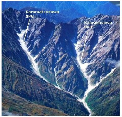
Figure 8: Karamatsuzawa SPG and Kaerazuawa SPG on the eastern slope of the north ridge of Mt.
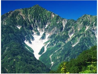
Figure 9: Kakunezato SPG on the north- east slope of Mt. Kashimayarigatake, northeastern Hida Mountains
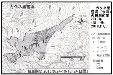
Figure 10a: Horizontal sketch of Kakunezato SPG in October 2015 (after Fukui et al., 2018)
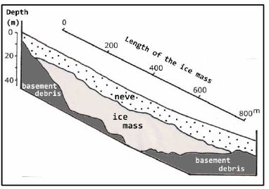
Figure 10b: Cross section of the Kakunezato SPG (Referred to Fukui et al., 2018)
Commentary on the Definition and Classification of Glaciers
There is so far no definition or criteria of recognition of glaciers officially decided by international as well as Japanese academic societies of related sciences. Merrian-Webster Dictionary [37] gives the definition of the glacier as “large ice body flowing slowly on the slope or along a valley, or large ice body on a large gentle land and flows outside from the land”, and a Japanese dictionary of earth science [38] describes “ice body existing on the surface of the earth and flowing continuously”. These descriptions may give a general understating of a glacier to people. However, we have to examine the correct definition, which is acceptable by scientists of related fields from the cryospheric academic point of view.
In the cryospheric world of Japan, explanations given by Ageta [35] and Shiraiwa [39] appeared in dictionaries of snow and ice convened by JSSI could generally be accepted by Japanese researchers of related fields, although Naruse [40], citing the definition of Flint [41], gives the explanation of a glacier as 1) large mass composed of snow and ice, and 2) existing on land and flows presently or flowed in the past.
The definition given by Flint [41] in his book Glacial and Quaternary Geology, “a large mass of snow and ice accumulated naturally and is mostly existing on the land, and is flowing presently or flowed in the past” is often referred to internationally. Reisco [42] pointed out that the International Association of Cryospheric Sciences and Intergovernmental Panel on Climate Change (IPCC) also show the similar definition.
In contrast, the IGS [43] has declared the agreement upon the Standard Practice Guide used by the Argentine Institute of Nivology, Glaciology and Environmental Sciences for making the National Glacier Inventory of Argentine, ① “a snow and ice mass with the dimension of less than 0.01 km2 is not included in the inventory, and ② definition of glaciers as “glacier is a perennial ice mass either stable or flowing” that appeared in the Argentinean Glacial Law. Raup [44] showed a candidate definition of the glacier related with the GLIMS (Global Land Ice Measurements from Space) Project of NSIDC (National Snow and Ice Data Center of US) [45] as “an ice mass existing over several years and has the dimension of more than 0.01km2 after the melting in summer”, and no description on the flow of the ice mass is given. The amount and thickness of ice mass within the snow and ice mass are considered to be critical for the recognition of a glacier, however, are not referred to in any descriptions of definition of glaciers so far disclosed. This point will be discussed in a later section.
Thus, there are two different ideas on the definition of glaciers regarding its flow signature, i.e., either “an ice mass stable or flowing” or “an ice mass flowing presently or flowed in the past”. The author prefers the former, because it is often almost impossible to clarify either an ice mass is a remnant of a past glacier or not. Since an ice mass has existed in a snow patch during this warm interglacial stage, it is possible that the ice mass of a past glacier of the glacial epoch have not disappeared and existed continuously throughout the interglacial stage. In such a case, it does not matter whether ice crystals forming the mass might have renewed time to time and no old crystals formed during the glacier epoch might have survived or not.
The principal classification of glaciers is based on temperature conditions (e.g., Ahlmann [46]; Journal of Glaciology, 1957) [47]. However, for snow and ice masses occurring in a restricted area, the above classification has almost no importance and instead, classifications based on the topographic characteristics are generally adopted (e.g., United Stage Geological Survey, 2004).
The International Committee on Snow and Ice (ICSI) planned under the International Hydrologic Decade (IHD, 1965-1974), with the objective to outline all snow and ice masses of the earth, and disclosed in 1967 a table of classification of glaciers (Table 1, UNESCO-IASH, 1970, described as ICSI table below) as the standard practice guide for making a world catalogue of snow and ice masses (the world glacier inventory) on the surface and sub-ground of the earth. The program of making the world inventory of glaciers has been succeeded to the IHP (1975), and in 1995 NSIDC started the renewal of the world glacier inventory project (GLIPS Project) [48], and the first report was delivered in 2014. In all the above international projects, the ICSI table has actively been used.
Table 1: Classification of snow and ice masses (UNESCO/IASH, 1970)
|
Digit 1 Primary classification |
Digit 1 Form |
Digit 3 Frontal characteristics |
Digit 4 Longitudinal profile
|
Digit 5 Major source of nourishment
|
Digit 6 Activity of tongue
|
|
| 0 | Uncertain or misc. | Uncertain or misc. | Normal or misc. | Uncertain or misc. | Uncertain or misc. | Uncertain or misc. |
| 1 | Continental ice sheet | Compound basins | Piedmont | Even; regular | Snow and/or drift snow.
|
Marked retreat
|
| 2 | Ice-field | Compound basin | Expanded foot | Hanging | Avalanche ice and/ or avalanche snow | Slight retreat |
| 3 | Ice cap | Simeple basin | Lobed
|
Cascading
|
Superimposed ice | Stationary |
| 4 | Outlet glacier | Cirque | Calving | Ice-fall | Slight advance | |
| 5 | Valley glacier | Niche | Coalescing, non-contributing | Interrupted
|
Marked advance | |
| 6 | Mountain glacier | Crater | Possible surge | |||
| 7 | Glaieiret & Snow field | Ice apron | Known surge | |||
| 8 | Ice shelf | Group of small unites | Oscilating | |||
| 9 | Rock glacier | Remnant |
The ICSI table has been used widely in the snow and ice academic world (e.g., Rau et al., [49]; JSSI, 2019). This table, however, was principally prepared to include all masses of snow and ice of the earth. That means that it includes not only all kinds of glaciers but also snow and ice masses such as snowfield, snow patch, ice shelf, etc., which are obviously not glaciers, and is thus practically the table for perennial snow and ice masses. The GLIMS Project disclosed a table principally same as the ICSI table, however, is supplemented by detailed explanations for each kind of snow and ice masses, and thus enables to give common and detailed classification of snow and ice masses in the world.
The constitution of the ICSI table, as shown on the Table 1 is briefly explained below. The table consists of 6 digits. In digit 1, all snow and ice masses on the earth are classified into 9 primary classes. Digits 2 to digit 6 are composed of characteristics of frontal shape, longitudinal profile, major source of nourishment, and activity of tongue of the 9 classes above, such as existence/absence, strength, size, etc. in 4 to 10 levels. Simple sketches and explanations are given for each class. Some explanations of the classes, which appear to be related with PSPs and SPGs of Japan mentioned above, are given below extracted from the explanations attached with the ICSI table.
Valley glacier: The glaciers of this class flow in the valley, and have clear nourishment area. Both side slopes of the valley are generally not covered by ice.
Mountain glacier: This class includes cirque, niche, and crater glaciers as major kinds, and apron, hanging and group glaciers also belong the same class. The topography of these glaciers does not show the development into the valley shape, however, the distinction between the valley and mountain glaciers are sometimes not easy.
Glacieret and snowfield: This class includes small masses of snow and ice with a variety of shapes that resist existing over 2 years. They are formed by drift, avalanche, or unusual precipitation on depressions, valley floor, or sun or window shades. They generally have no indication of flow. It is difficult to clearly distinguish between the glacieret and snow patch. Nourishment and ablation areas are sometimes not identified.
The explanation of ICSI table given on the glacieret appears difficult to understand because the table explains altogether with glacieret and snowfield. The Cryosphere Glossary given by NSIDC, which is considered to be intimately related with the GLIMS Project describes the glacieret as “a very small glacier”. To examine altogether the above, we understand that the glacieret and snowfield given in the ICSI table is composed of two groups, i.e., the glacieret, which is a very small glacier, and the snowfield, which includes snowfield, snow patch, and snow deposit. There is no clear evidence of flow in both of the above groups.
The ICSI table is, as mentioned above, completely different from proper dictionaries cited above. It classifies all kinds of snow and ice masses and gives detailed explanations. Further the manual of glacier classification by GLIMS cited above gives further detailed explanations on many kinds of glaciers of the table. In this classification, all snow and ice masses except snowfield, snow patch, ice field and ice field are identified as glaciers. That means that a snow and ice mass which is classed into either one of the classes 1, 3, 4, 5, 6, 9, and glacieret of 7 of the ICSI table is identified internationally as a class of the glaciers. In conclusion, the ICSI table is further useful and clear than ordinary dictionaries of related science world to define either a snow and ice mass is the glacier or not, and in what class of the glacier it belongs.
To avoid confusion on the definition and classification of glaciers, the usage of the international definition of glaciers (IGS, 2017) [43] and ICSI table is preferable. Actually in Japan, JSSI discloses the same table (with Japanese translation by G. Wakahama – [50]) as the model for the world inventory of snow and ice masses.
In the above ICSI table including detailed explanations of GLIMS, indexes on the size of the snow and ice mass and speed of flow are not shown, and thus, a variety of snow and ice masses with no flow and with a variety of sizes are included. There is no description on the flow signature for the mountain glacier, and for the glacieret, a description “no obvious flow is recognized” is given. For other glaciers, for which the flow of the mass is mentioned, there is no constraint on the speed and mechanism of the flow and the inner structure of the mass, and even on what part of the snow and ice mass flows is not given. Further for all snow and ice masses, no description on the past or future flow is given.
It may be reasonable that the description on the flow is not necessary in the ICSI table, since the table was principally made with the objective (UNESCO/IAASH, 1970) [51] of clarifying the amount and the income and outcome of snow and ice of the earth. However, since the table is to be used now, to cover all snow and ice masses of the earth and to show their major signatures apart from its original objective, existence/absence of and speed of the flow, size, and amount of ice mass of a snow and ice mass are expected to be added to the ICSI table as the 7th-9th digits.
UNESCO/IASH (1970) [51] disclosed examples of usage of the ICSI table for making the world glacier inventory for snow and ice masses, in the North Polar region, Rocky Mountains and Himalaya in pilot field studies, showed general examples of field evidence of dimensions and ice thicknesses for some classes of glaciers as follows.
Valley glaciers: 1-100 km2 in dimension and 30-120 m in ice thickness.
Mountain glaciers: 0-20 km2 in dimension and 20-120 m in ice thickness.
Glacierets: 0-2 km2 in dimension and 10-25 m in ice thickness.
As mentioned above, the critical smallest limit for the dimension of a snow and ice mass as 0.01km2 is considered to have become used worldwide for making the world inventory (e.g., Paul et al. [52]; IGS, 2017) [43]. The Journal of Glaciology [47] once showed the idea that an ice mass of less than 15m in thickness could not be included in the inventory. However after that, the ice thickness of 15 meters appears not become common for the registration in the inventory. Muller (1970) [53-56] in his pilot study in the Himalaya showed several glaciers with the ice thickness of 8 meters, although the thickness was not practically measured.
Muller [53] in his study of glaciers in the Everest area of eastern Himalaya as the pilot study of UNESCO/IASH (1970) [41], showed many examples of signature (length, width, ice thickness, etc.) of glaciers. Some examples of his description are given in Figures 11, 12 and Table 2. In his study, the valley glaciers develop generally in a large, long and gentle valley and the snow and ice mass is very large, thus, the distinction from mountain glaciers are generally clear. However, there are found some exceptional cases that a short glacier developed on a steep mountain slope is also classed as the valley glacier. Almost all mountain glaciers are classed as the cirque glacier or unclassed, and only 2 glaciers among 121 mountain glaciers are classed as the niche glacier. Only 2 glacierets are shown in the report and they develop on steep mountain slopes and the distinction from the mountain glacier is not clear.
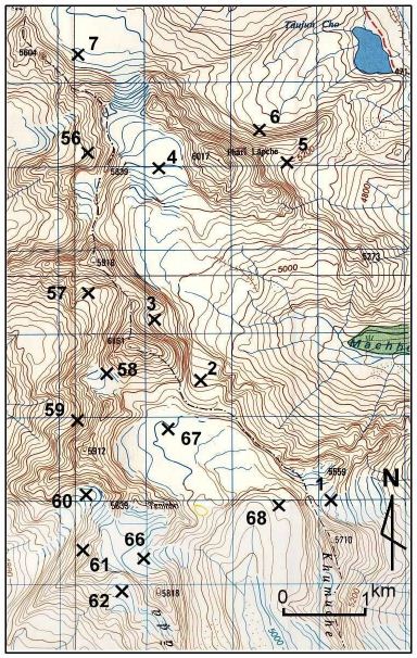
Figure 11: Glaciers surrounding Kyajo Ri, west of Dudhu Koshi, Everest area. Numbers show glacier numbers and locations reported by Muller, 1970.
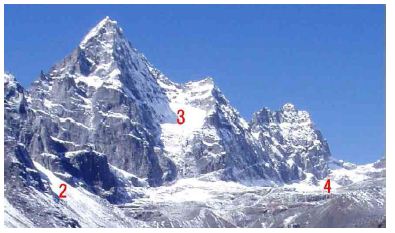
Figure 12: The western slope of Kyajo Ri, with glaciers (numbered) described by Muller (1970)
Table 2: Description of glaciers in the area of Fig. 10 (surrounding Kyajo Ri) by Muller (1970). The classification numerical numbers are given by Muller following the Table 1.
|
Glacier No.
|
Classification
|
Length km
|
Dims km2
|
Ice thick m
|
| NEA45C-55 |
600011 |
1 |
0.29 |
13 |
| NEA45C-56 |
600011 |
1.1 |
0.36 |
14 |
| NEA45C-57 |
602311 |
1.4 |
0.52 |
18 |
| NEA45C-58 |
600210 |
0.8 |
0.06 |
10 |
| NEA45C-59 |
640020 |
0.4 |
0.06 |
10 |
| NEA45C-60 |
640021 |
1 |
0.24 |
20 |
| NEA45C-61 |
700210 |
0.9 |
0.11 |
10 |
| NEA45C-62 |
600210 |
0.5 |
0.13 |
12 |
| NEA45C-63 |
600210 |
0.2 |
0.06 |
10 |
| NEA45C-64 |
600310 |
1.1 |
0.06 |
10 |
| NEA45C-65 |
640022 |
0.4 |
0.15 |
12 |
Referring all the above, SPGs of Japan developed in small valleys and have been identified as glaciers are considered to belong the mountain glacier, glacieret, or valley glacier. Fukui et al. [29] classed all 6 SPGs they reported to belong the mountain glacier, among which 4 glaciers as the niche, and 2 as the cirque glaciers. The author, however, prefers to classify most of those glaciers as the valley glacier, since these SPGs develop in deep and clear valley topography, which are different from niche.
The cirque glacier is considered to be the glacier that contributed principally to form the cirque topography. Two glaciers classed as the cirque glacier by Fukui et al. [29] are not clear either they contributed to the formation of the concerned cirque topography or not, and therefore they could be provisionally classed as the valley glacier or glacieret.
Summary and Discussion
- The glaciological study on perennial snow patches (PSPs) in Japan has been conducted continuously since around 1917. Since 1970, glaciologic data were summarized by K. Higuchi and others for wide areas in Japan. In 2012, 3 PSPs in the Hida Mountains were identified as the active glacier, and the Data Center for Glacier Research of JSSI had an open symposium to examine the above identification. The symposium positively recognized it, appreciating the existence of distinct flow of the ice mass as the important criterion for the identification of the glacier.
- The definition and classification of glaciers are examined referring various references. There are two different ideas on the definition of glaciers regarding its flow signature, i.e., either “an ice mass stable or flowing” or “an ice mass flowing presently or flowed in the past”. The author prefers the former, because it is often almost impossible to clarify either an ice mass is a remnant of a past glacier or not. Regarding the dimension, 0.01 km2 is also the widely accepted criterion as the smallest limit, and there is no constraint on the dimension and thickness of the ice mass within a snow and ice mass.
- The definition of a glacier given in common dictionaries gives only a general signature of glaciers and does not include all kinds of glaciers. The glacier classification table by ICSI, in contrast, includes all kinds of glaciers and provides detailed characterization of them, and therefore useful to define, identify and classify all kinds of glaciers and snow and ice masses, although the table includes snow and ice masses such as snowfield and iceshelf, which do not clearly belong the glacier.
- The international glacier classification table of ICSI has been used widely in international bodies and projects. This table, however, was made with the objective of classifying all kinds of snow and ice masses of the earth, and therefore includes all kinds of glaciers as well as snowfield, snow patch, ice shelf etc., which are obviously not the glacier.
- Large (larger than 0.01km2 in dimension) perennial snow patches in Japan with considerable size of ice mass within it are classified as glacieret, mountain glacier or valley glacier. The distinction among the above three kinds of glaciers, however, includes some uncertainties, and ideas of classification is not definite at present.
- Judgement criteria to identify a snow and ice mass as the glacier is simple following the international definition. Size of the ice mass within a snow and ice mass, identification of flow, speed of flow, inner structure, and mechanism of flow of the ice mass are important to understand the glaciological signature of the ice mass, but not necessary for the identification of the glacier.
- The present international classification table of glaciers (ICSI table) includes some uncertainties and needs to include some components in the criterial signatures such as: existence/absence of flow of ice, and size of the ice mass. Further, some more characterizations for the discriminations among valley glacier and mountain glacier, mountain glacier and glacieret, niche glacier, glacieret and snow patch are considered necessary. The present nomenclature of one of the principal classes of the ICSI table, the mountain glacier, is confusing, because it is generally understood as glacier developed in mountains. An appropriate name such as the mountain slope glacier proposed by G. Wakahama (in JSSI, 1970) may be worth consideration. These points are important to clearly classify a snow and ice mass and requested to be examined in the related science world.
Acknowledgement
The present author is indebted to Dr. Renji Naruse of the Glacier and Cryospheric Environment Research Laboratory in Japan, who gave important advices at the beginning of the precursory Japanese manuscript and also provided a photo of the Aretch Glacier, and Mr. Jinyu Akabane and Dr. Chiyuki Narama who provided photos of snow patch glaciers of the Hida Mountains.
Reference
- Fukui K, Iida H (2012) Identifying active glaciers in Mt. Tateyama and Mt. Tsurugi in the northern Japanese Alps, central Japan (in Japanese).Seppyo ( Jap. Soc. Snow Ice) 74: 213-222.
- Japanese Society of Snow and Ice home page, 2018].
- Yoshida Masaru (2019) Glaciers of Japan and world-from an excursion to view the Kakunezato glacier, 1 and 2 (in Japanese). Chigaku kyoiku to kagaku undoh (Education in Geoscience and Movement for Science) 83: 56-62 and 84: 64-70.
- Yoshida Masaru (2020) Active glaciers in Japan-Definition and classification of glaciers (in Japanese)*. Chishitugaku zasshi ( Geol. Soc. Japan) 126: 149-156.
- Ohzeki K (1917) On perennial snow patches in Gassan, Uzenkoku* (in Japanese). Chishitugaku Zasshi ( Geol. Soc. Jap) 24: 366-373.
- Imanishi K (1929) On perennial snow of Tsurugizawa*(in Japanese). Chikyu (The Earth) 11: 267-
- Sakita R (1931) On an ice mass lying at the valley head of Gozenzawa, Tateyama* (in Japanese). Chirigaku hyouron ( Rev., Jap.) 7: 734-747.
- Iozawa T (1959) A note on Kakunezato (in Japanese).Chiri (The Geography) 4: 96-104.
- Ogasawara K (1964) Glaciers in the Northern Japanese Alps: a proposal of the distinctive temperate glaciers* (in Japanese). Toyama Daigaku Gakujutu Chosa-dan, (Academic Research Group of Toyama Univ.)* Ed, Pg: 5-34. Kokon Shoin, Tokyo.
- Yoshida J (1964) Glaciological survey of perennial snow patches in Tateyama* (in Japanese). Toyama Daigaku Gakujutu Chosa-dan, ed. Tateyama no mannenyuki no.
- Wakahama G, Endo Y, Yamada T, Ushiki H, Naruse R (1968) Studies of firn on Mt. Daisetsu in summer,III (in Japanese). Low Temperature Science, A, 26: 215-229.
- Higuchi K (1968) A review of the glaciological studies on perennial ice and snow masses in Japan (in Japanese). Seppyo ( Jap. Soc. Snow Ice)30: 195-207.
- Higuchi K (1979) Collected papers on perennial snow patches in Japan (1) (in Japanese). Seppyo ( Jap. Soc. Snow Ice) 41:1-7.
- Higuchi K, Watanabe O, Ushiki H, Okudaira H, Ageta Y (1971) Glaciological studies on the perennial snow patches in Tsurugizawa, Part I -Glaciological studies on the perennial snow patches in Tsurugizawa, Part I- (in Japanese). Seppyo ( Jap. Soc. Snow Ice) 32: 129-146.
- Higuchi K, Ohata T, Watanabe O (1979a) Change in the size of the “Hamaguriyuki” perennial snow patch on Mount Tsurugi, central Japan (in Japanese).Seppyo ( Jap. Soc. Snow Ice) 41: 77-84.
- Higuchi K, Wakahama G, Yamada T, Naruse R, et al., (1979b) A summary on the studies of perennial snow patches in Japan (in Japanese). Seppyo ( Jap. Soc. Snow Ice) 41: 181-197.
- Tsuchiya I. (1974) Survey on glacierets in Chokaizan* (in Japanese). Chiri (The Geography) 19: 51-59.
- Tsuchiya I (1976a) Kaigata Glacieret in Chokaizan (in Japanese). Chiri (The Geography) 26: 19-28.
- Tsuchiya I (1976b) Annual deviation and its meteorological analysis of glacierets in Chokaizan* (in Japanese).Tenki (The Weather) 23: 53-56.
- Tsuchiya I (1976c) Airborne photogrametrical estimations of extraordinary snow depths in Mts Iide, Gassan and Chokai and a preliminary report n the birth of a small glacier. Seppyo ( Jap. Soc. Snow Ice) 38: 22-31.
- Tsuchiya I (1977) The Glacio-climatological study on the Kaigata Glacieret, Mt. Chokai (1) Inter annual variation and structure of annual boundary layers (in Japanese). Seppyo ( Jap. Soc. Snow Ice) 39: 201-212.
- Tsuchiya I (1978a) The glacio-climatological study on the Kaigata Glacieret, Mt. Chokai 2, Instrumental surveys of shape and size and movement measurements (in Japanese). Seppyo ( Jap. Soc. Snow Ice) 40: 1-9.
- Tsuchiya I (1978b) The Glacio-Climatological Study on the Kaigata Glacieret, Mt. Chokai (3) Thermal analysis in combination with remote sensing and some features as glacier (in Japanese). Seppyo ( Jap. Soc. Snow Ice) 40: 10-21.
- Tsuchiya I (1999) Nihon no mannenyuki (Perennial snow patches in Japan)* (in Japanese). Kokon Shoin, Tokyo
- Matsuda M (1976) Structure of perennial snow patches in Mt. Daisetsu area, Hokkaido (in Japanese). Seppyo 38: 115-126.
- Yoshida, Minoru, Yamamoto K, Higuchi K, Iida H, et al., (1990) First discovery of fossil ice of 1000-1700 year B.P. in Japan. Glaciol. 36: 258-259.
- Kawashima K, Noguchi Y, Kobayashi T, Sato M (2000) Glaciological investigations of the Yamunaisawa perennial snow patch by means of shallow core drillings (in Japanese).Rishiri Kenkyu (Rishiri Research) 19: 79-87.
- Fukui K, Iida H, (2013) Reply to “Comments on identifying active glaciers in Mt. Tateyama and Mt. Tsurugidake in the northern Japanese Alps, central Japan” by I. Tsuchiya (in Japanese). Seppyo ( Jap. Soc. Snow Ice) 75: 147-149.]
- Fukui K, Iida H, Kosaka K (2018) Newly identifying active glaciers in the northern Japanese Alps and their characteristics (in Japanese). Chirigaku hyouron ( Rev. Jap.) Ser A 91: 43-61.
- Arie K, Narama C, Fukui K, Iida H, Takahashi K (2019) Ice thickness and flow of the Karamatsuzawa snow patch, northern Hida Mountains. Seppyo ( Jap. Soc of Snow and Ice) 81: 283-295.
- Yoshida Masaru (2022) Snow patch glaciers surrounding Hakuba village, Nagano Prefecture―possibility of forming a glacier park/geopark (in Japanese)*. Chigaku kyoiku to kagaku undoh (Education in Geoscience and Movement for Science) 89: 25-34.
- Hoshiai M, Kobayashi K (1957) A theoretical discussion on the so-called “snow line”, with reference to the temperature reduction during the Last Glacial Age in Japan. Japanese Journal of geology and Geography, 28: 61-75.
- Ono Y (2012) Studies on glacial landforms in Japan between 1960 and 2010: Personal review (in Japanese). Chigaku Zasshi ( Geogr) 121: 187-214.
- Shiraiwa T, Naito N, Iida H, Fukui K (2012) Report of the Public Symposium of the Center for the Glacier Research Information: Perennial snow patches and glaciers in Japan-Previous research and a future view* (in Japanese). Seppyo ( Jap. Soc. Snow Ice) 74: 353-357.
- Ageta Y (1990) [Glacier] and [Glacier flow], in Japanese Society of Snow and Ice (Ed.), Dictionary of Snow and Ice (in Japanese), Kokon Shoin, Tokyo, p. 100 and p.103.
- Geospacial Information Authority of Japan (2018) Denshikokudo.
- Merrian-Webster Dictionary (2018) Definition of glacier.
- Toya H, Iwata S (1996) Chigaku Jiten, New Edition* (in Japanese), Ed. Commit Chigaku Jiten (Dictionary of Geoscience). Geol. Collab. Jap 1993.
- Shiraiwa T (2005) Definition, Classification and Movement of Glacier* (in Japanese). Japanese Soc. Snow Ice (superv)*, Dictionary of Snow and Ice*, 277-287.
- Naruse R (2013) Dictionary of Glacier and Cryosphere, 5th Edition (in Japanese). Glacier and Cryospheric Environment Research Laboratory HP, 2018.
- Flint RF (1971) Glacial and Quaternary Geology. Wiley and Sons NY 39-44.
- Reisco M (2015) Glacier resources law and policy: A case of transboundary management. In: International Water Resources Association (IWRA) HP.
- International Glaciological Society (2017) Position paper of the International Glaciological Society on standard practices regarding glacier inventories. IGS-HP.
- Raup B (2006) Proposed GLIMS Definition of “Glacier”.
- NSIDC (National Snow and Ice Data Center), 2019, Cryosphere Glossary. In: NSIDC HP.
- Ahlmann H (1935) Contribution to the physics of glaciers. J 86: 97-113.
- Journal of Glaciology (1957) The Classification of Glaciers. Glaciology 3: 21, 2-7.
- Pfeffer WT, Arendt AA, Bliss A, Bolch T (2014) The Randolph Glacier Inventory: a globally complete inventory of glaciers. Glaciology 60: 537-552.
- Rau F, Mauz F, Vogt S, Khalsa SJS, Raup B (2005) Illustrated GLIMS glacier classification manual. GLIMS Regional Center ‘Antarctic Peninsula’, Pg: 1-36.
- Wakahama G (1978) Translation from “A guide for compilation and assemblage of data for a world inventory, IHD Resolution, 1967” (in Japanese). Soc. Snow & Ice HP.
- UNESCO-IASH (1970) Technical papers in hydrology, 1. Perennial ice and snow masses, a compilation to the International Hydrological Decade. UNESCO, Paris, Pg: 1-53.
- Paul F, Barry RG, Cogley JG, Frey H, et al., (2009) Recommendations for the compilation of glacier inventory data from digital sources. Annals of Glaciology 50: 119-126.
- Müller P (1970) A pilot study for an inventory of the glaciers in the Eastern Himalaya. In: UNESCO-IASH, 1970, Perennial ice and snow masses Pg: 47-59.
- Fountain AG (2006) Proposed GLIMS definition of “glacier”. In: NSIDC-HP, 2019.
- USGS (United States Geological Survey) (2017) Types of glaciers. In: Glossary of Glaciers Terminology – text version, USGS Homepage.
- seppyogakuteki chousa (cryospherical survey of perennial snow patches in Tateyama). In Tateyama no Shizen (Nature of Mt. Tateyama)*, 5-34.Kokon Shoin, Tokyo.