Abstract
During the early fragmentation of Pangaea in the Early-Middle Jurassic, sea corridors divided the single supercontinent into distinct terrestrial provinces. In the Northern Hemisphere, epicontinental seas separated central Eurasia into east and west territories during the Jurassic and Cretaceous periods. This study uses the available paleogeographical data to investigate the early exposure regime of the Middle Russian Sea on the Jurassic Russian Platform. To date, the extended pauses in sedimentary deposition have blurred detailed paleogeographical reconstructions. This study defines the Boreal Sequence Set (BSS) as the sea level fluctuation pattern that dominated the Russian Platform during the Jurassic and Cretaceous periods and reconsiders the facies of the available stratigraphical sections in a new paleogeographical synthesis. Certain stratigraphical evidence suggests that the Middle Russian Sea was initially exposed as a whole in the latest Aalenian (~171 mya, under a low-salinity setting). The sea continuity was re-interrupted during sea level low-stands of the BSS: from the earliest Bajocian (the BJ1 sea level low-stand, ~170 mya) to the late Early Bajocian (~168.5 mya), in the latest Bathonian (the Bat5 sea level low-stand, ~166 mya), and in the Middle Oxfordian (the OX5 sea level low-stand, ~160 mya). The OX5, in particular, dramatically affected the Russian Platform stratigraphy, representing a prominent sea level fall.
Keywords
Middle Russian Sea, Russian platform, Jurassic, Paleogeography, Oxfordian Sea level, Pangea breakup
Introduction
During the mid-Carboniferous period (~330 mya), contact between Gondwana and Laurussia led to the formation of a huge supercontinent, the Pangaea [e.g., 1-2]. The single terrestrial environment allowed the biota of the supercontinent to disperse over long distances, resulting in the appearance of common morphotypes in the fossil record on separate and remote continents. It was the acknowledgment of the common morphotypes that first led Wegener [3] to hypothesize the existence of a single supercontinent, which was later named Pangaea. The fragmentation of Pangaea during the Early-Middle Jurassic, after tens of millions of years of terrestrial continuity, led to the geographic isolation of biotic populations, allowing speciation through vicariance [e.g., 4].
In the Northern Hemisphere, in addition to the formation of long and narrow seaways such as the “Hispanic Corridor” between Gondwana and Laurasia [5-6] and the “Viking Corridor” between North America and Eurasia [7], the exposure of epicontinental seas [that is, the Middle Russian Sea (MRS; on the Russian Platform west of the Ural Orogenic Belt) and the West Siberian Sea (in the West Siberian Basin east of the Ural Orogenic Belt)] in central Eurasia separated Eurasia into east and west territories during the Jurassic, Cretaceous, and Paleogene periods (Figure 1). In the current study, the available paleogeographical evidence is reconsidered, evaluated, and discussed under a new synthesis in order to investigate the temporal and spatial regime under which the epicontinental MRS was initially exposed. The period under consideration includes the Early to Late Jurassic (up to Oxfordian).
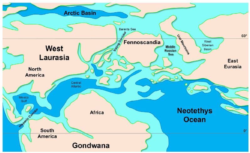
Figure 1: Late Jurassic simplified paleogeographical reconstruction showing the isolated terrestrial territories of the Northern Hemisphere after the early fragmentation of Pangaea. The West Siberian Sea is closed southwards at this time. Dark gray: land; light gray: shallow shelves; white: deep-sea. Map modified from ref. [73]. Paleolatitudes after ref. [74].
Materials and Methods
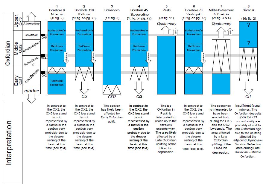
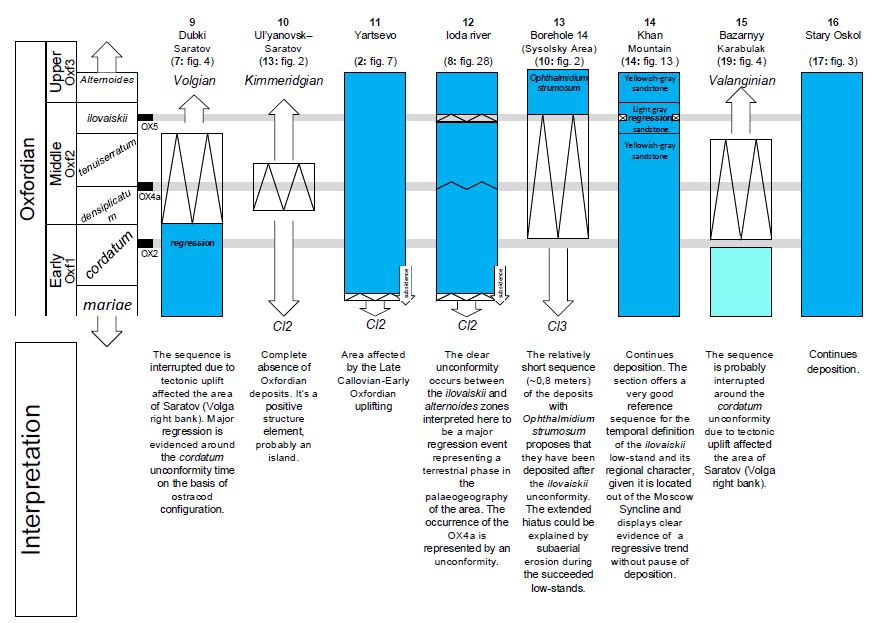
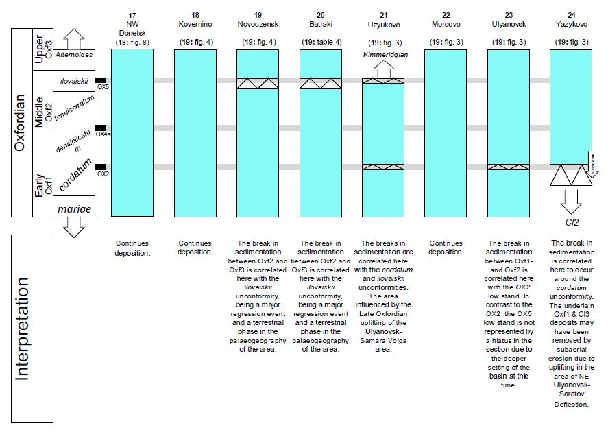
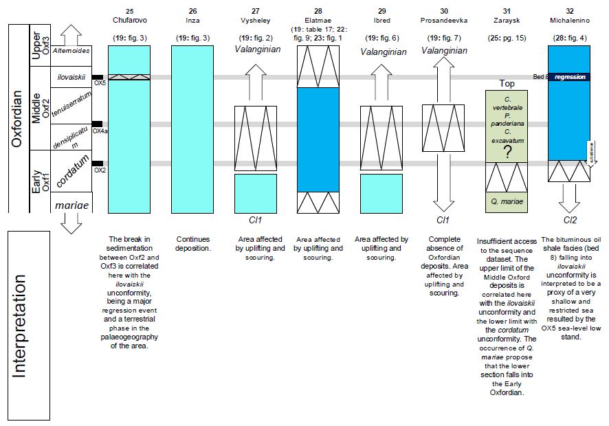
Several paleogeographical reconstructions of the time interval of interest have been published over the past 50 years for the whole area [e.g. 8-9] or exclusively for the northern region [e.g., 10-15] of the Russian Platform. There are no published paleogeographical reconstructions that include the whole extension of the MRS for the time period of interest with temporal resolution other than on the order of geological ages (e.g. Callovian, Oxfordian) and sub-ages (Early, Middle, Late). Such reconstructions may have gaps of millions of years between them and rarely refer to sea level low-stands because they are normally intended to display the maximum extension of the sea. Therefore, they are unable to demonstrate ephemeral, short-lived interruptions of the seaways, which are of great importance for understanding the biogeographical evolution of the terrestrial biota. This is the main target of the current study. Major hiatuses in the Jurassic stratigraphy of the Russian Platform prevent exact estimations of the past extension of land-sea boundaries because it is not clear whether a phenomenal cease of deposition is due to a real contemporaneous pause or to erosion in later epochs as a result of subaerial exposure and/or scouring from subsequent transgressions. On the other hand, it is also difficult to know whether the eroded sectors in stratigraphical schemes are the result of uplifting or sea level fall. In order to better understand the stratigraphic schemes, this study considered updated tectonic data (Figure 2) and made special effort to investigate the sea level fluctuations that influenced the area (Figure3). The latter is easier if one considers that first-to-third-order transgression-regression cycles (108-106 years) correspond to tectonic procedures, while fourth-to-fifth-order cycles (105-104 years) correspond to eustatic fluctuations [e.g., 16]. Hiatuses and unconformities in the stratigraphy of shallow epicontinental seas could correspond to subaerial erosion from sea level low-stands whenever the magnitude of sea level fall surpasses the depth of a given marine surface. When the depth is greater and up to a critical value (after which diagenetic conditions are not affected by sea level change), changes in represented facies could be an effect of sea level change on diagenesis [e.g., 17]. On the basis of those principles, one of the best studied and described sections from the margin of the central Russian Platform (that from the Iloda River; Figure 3) is considered here as a reference for sensing the sea level fluctuations that affected the area. Specific cross-sections that include important information about the sea level fluctuations in the area are also examined (Figure 4). All such sections were sampled from areas without any known tectonic activity at the time of sedimentation. About 100 stratigraphical sections from the literature are informative for the paleogeographical reconstruction of the Oxfordian Russian Platform and are interpreted mainly on the basis of the reference sea level fluctuation signal (see the Supplementary Appendix). A lesser number are considered for the Middle Jurassic interval, for which stratigraphical schemes are taken from the Regional Stratigraphic Scheme of the Russian Platform [18]. Special effort is taken in reconstructing the paleogeography during the sea level low-stand periods in order to investigate possible interruptions of the MRS. The paleogeographical reconstructions of Sasonova and Sasonov [8] provide the basic reference for the current study regarding the Oxfordian Russian Platform. Updated data have been obtained from published works on stratigraphical outcrops and boreholes as well as various paleogeographical reconstructions of partial areas of the territory. Spatial gaps in stratigraphical sampling have been overcome by supposing continuity in the exposure of the sea on the basis of the marine faunal similarity, which in turn can support faunal exchange. Finally, the opinions of specific Russian specialists regarding the paleogeographical evolution of parts of the Russian Platform have been taken into consideration and included in the reconstruction of the paleogeographical maps.
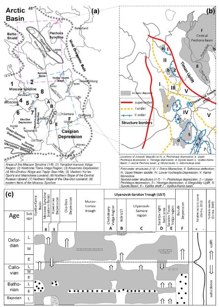
Figure 2: (a) General view of the study area including major tectonic and physiographical elements. The gray dotted lines delineate the borders of the Russian Platform. Map after ref. [29,75]. (b) Early Permian structures of the North Russian Plate and distribution of Jurassic deposits. Map modified from ref. [10]. The thin dotted lines mark the borders of the Timan-Ural Trough (TUT), the main geomorphologic structure through which the Pechora Syncline probably communicated with the Lower Vychegda Depression, according to the conclusions of the current study. (c) Main tectonic trends in the central Russian Platform during the Middle to Late Jurassic. Letters and numbers correspond to areas pictured in section (a). Modified from ref. [26-27,76].
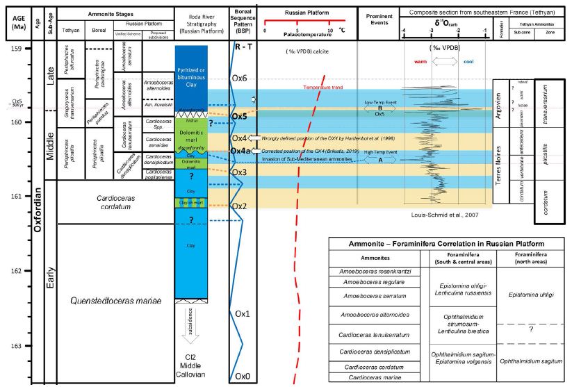
Figure 3: Sea level change on the East European (Russian) Platform during the Oxfordian. The Illoda cross-section is modified from ref. [34: Figure 28]. Boreal sequence sets and chronostratigraphy after ref. [33]; paleotemperature curve after ref. [77]; Borean-Tethyan- Russian Platform ammonite biozone correlation and foraminifera zonation after ref. [18,33]. Tethyan Oxygen Isotope Stratigraphy after ref. [38]. For faunal and main events, see the text. Question marks correspond to insufficient biozone boundaries by the original authors.
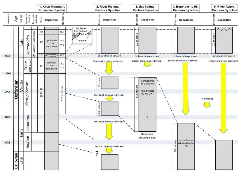
Figure 4: Proposed samples of tectonically unbiased outcrops from the East Pricaspian Syncline (Section 1: Khan Mountain, Berdanka River) and the Pechora Syncline (Section 2: estuary of River Pizhma; Section 3: Ust-Tsilma area; Section 4: Borehole no 98, Denisovskaya; Section 5: River Adzva). The observed facies have been interpreted as evidence of the successive T/R cycles of the BSP. Sections modified from ref. [14,44].
This study is focused on the biogeographical role of the MRS, so the paleogeographical reconstructions focus on the occurrence of the sea as a barrier to the dispersal of the terrestrial biota and not on the maximum past extension of the seas. Thus, given that hiatuses in stratigraphical sections could be due to scouring and not to subaerial erosion (weathering), obfuscating the extent of the sea-land boundaries, the reconstructed paleogeographical maps in this study should be considered to display a minimum of the past sea extension, rather than a maximum, especially during the intervals of sea level low-stands.
Results
Tectonic Setting
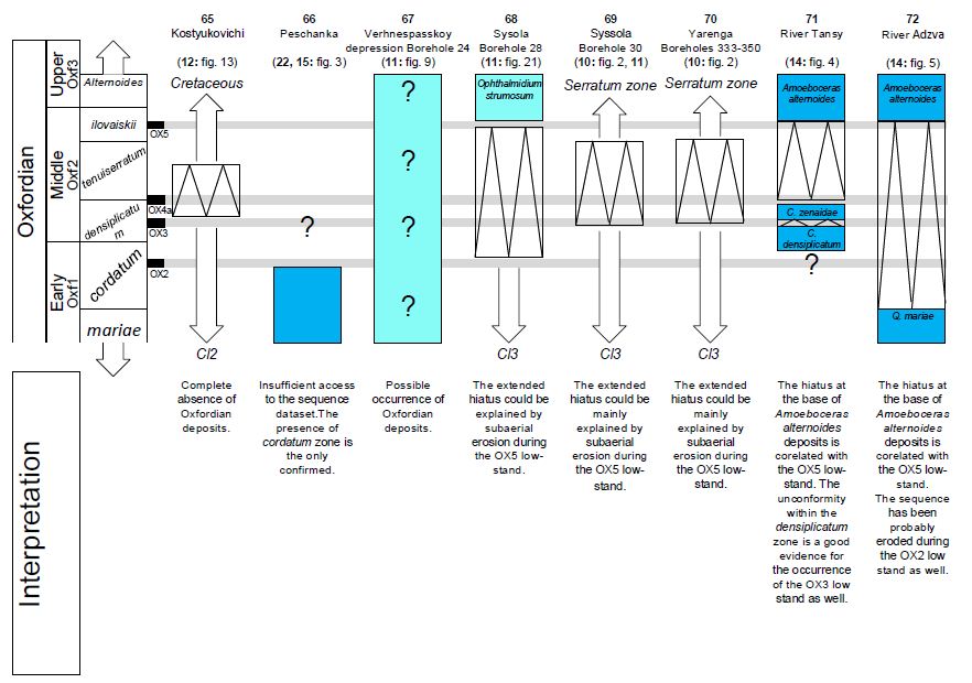
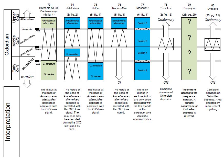
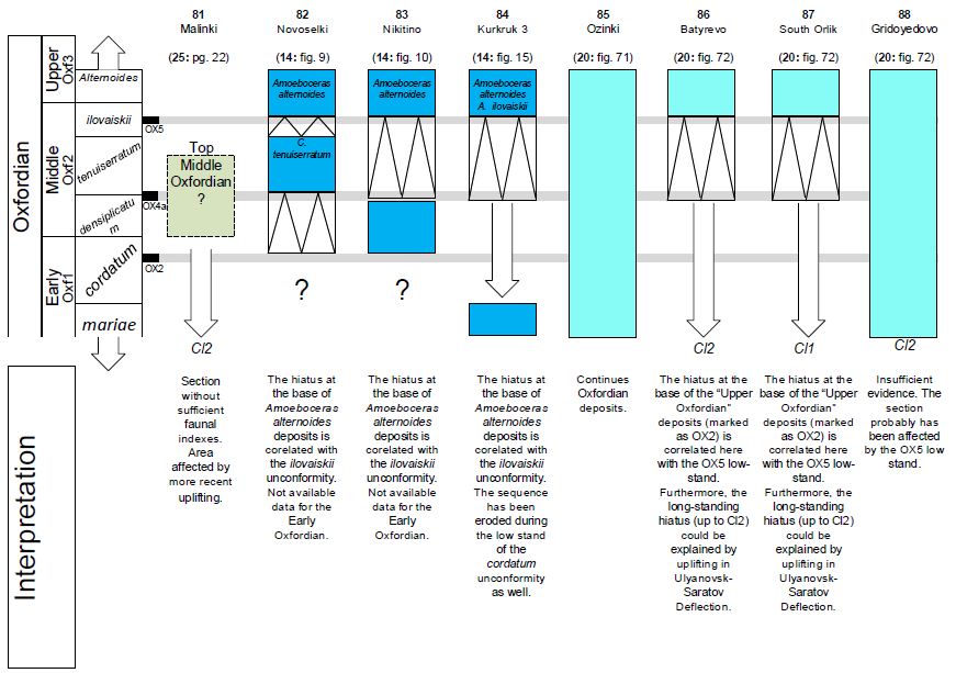
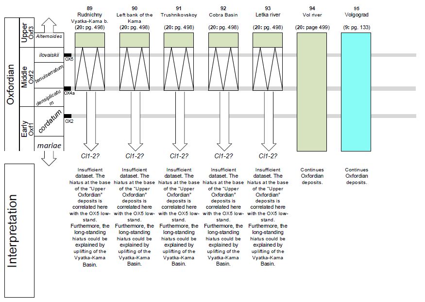
The Russian Platform is a part of the Baltica terrain, which during the Early Paleozoic (Silurian) accreted the Laurentia and Avalonia terrains [1-2] to form the super-terrain of Laurussia through the Caledonian Orogeny [19-20]. During the late Carboniferous, the Kazakhstanian terrain collided with Laurussia, resulting in the Uralian Orogeny and forming the Ural Orogenic Belt, which makes up the eastern border of the East European (Russian) Platform [21]. The Siberian terrain did not add to the accretion until the Late Permian [2]. The main structures of the sedimentation cover of the Russian Platform have been formed through reorganizations that took place from the late Proterozoic to the latest Paleozoic (Permian), while the vast synclines of the platform were formed in later epochs [22]. During the Early Permian, the Moscow and Mezen Synclines merged, forming a single North Russian Platform syncline, which was transgressed during that epoch [23]. The Jurassic transgressions were spread on the Early Permian structural plan, although during the Triassic, the Permian structural elements were smoothed and blurred by subaerial erosion [ref. 10 and references therein]. Structurally, the Pechora Syncline belongs to the East Barents Sea plate and not to the East European Platform, which is separated from it by the Timan Uplift [24]. During the Middle Jurassic, a meteorite impact in the Kovernino Depression resulted in a complex stratigraphy and the occurrence of volcanic sediments (see ref. [25] and references therein). Zorina [26] summed up the current knowledge of the Jurassic tectonic activity in the central Russian Platform, concluding that the Jurassic transgression initiated on a regional subsidence during the earliest Bajocian, resulting in continuous deposition until the Middle Callovian. A regional uplifting episode that started in the Late Callovian culminated in the Early Oxfordian and then subsided up to the end of the Middle Oxfordian. The areas affected by the uplifting are the Vyatka-Kama Basin and parts of the Ulyanovsk-Saratov Deflection (the Cheboksary Volga, the Northeast area, the Ulyanovsk-Samara Volga, and the Saratov right bank [Volga]; see Figure 2a and 2c). More recently, Zorina [27] located the peak of that uplifting trend at the Callovian-Oxfordian boundary. Olferiev [28] doubted the assumption of Sasonova and Sasonov [8] regarding the subaerial exposure of the Voronezh Anticlise during the Jurassic and gave an alternative explanation for the extensive hiatus observed in the area. In particular, on the basis of the observed facies, the stratigraphical range and composition, and the correlation of the formations on either side of the anticlise, Olferiev [28] argued that the Voronezh Anticlise (the Don land of Sasonova and Sasonov [8]) was under the sea during the Jurassic and that the Jurassic depositions either are currently covered by thick Cretaceous sediments or have been eroded by uplifting episodes in more recent periods. This study takes both interpretations [26,28] into consideration. The area of the Voronezh Anticlise is displayed with a question mark inside the subaerial borderline of Sasonova and Sasonov [8] because of the conflicting hypotheses. In the northern area of the Russian Platform, the role of the Timan Uplift in the paleogeography of the area is not well established. Different authors have expressed different views on whether the Timan Uplift resulted in a subaerial, underwater, single, or fragmentary (a series of islands) barrier to marine faunal exchanges between the Pechora Syncline and the areas to the west and south during the different Jurassic ages [e.g., 8,10-13]. In the paleogeographical reconstructions of this study, the Timan Belt is displayed as separated from the Ural Orogenic Belt by a low relief structure, which here is called the Timan-Ural Trough (TUT; Figure 2c). This trough allowed the southwards communication of the Pechora Syncline with the Sysola Basin without any barriers since the Early Jurassic. Its existence has been hypothesized to explain the stratigraphical and biostratigraphical similarities between the two areas (see below).
The Sea Level Fluctuation Pattern that Affected the Russian Platform
Sahagian et al. [29] published one of the most detailed and realistic sea level fluctuation curves on the basis of stratigraphical evidence from the Russian Platform. However, its resolution (normally one to two samples per ammonite zone) is not enough to cover the requirements of the present study. A previous effort to correlate the Exxon’s sequence set [30] in the Russian Platform failed to find a good correspondence on the Callovian and Late Jurassic sequence boundaries. Instead, a good correlation was found between the lithostratigraphic sequence boundaries of South England and the Moscow Syncline [31]. Indeed, as shown below, a correlation with the Boreal sequence sets of Hardenbol et al. [32], calibrated on the GTS2012 [ref. 33: Figure 26.9; see also Figure 3], gives a very good correspondence [from now on, and by this calibrating form, this sequence will be called the Boreal Sequence Pattern (BSP)].
Data from the Reference Illoda River Section
One of the most well studied and detailed stratigraphical sections, that of the Illoda River [34] on the central Russian Platform, is used here as a reference section for the previously mentioned correlation (Figure 3). The section displays a Middle Callovian-earliest Oxfordian hiatus, probably as a result of a previous uplifting, but it also displays continuous and very informative sedimentation since the earliest Oxfordian. The occurrence of the Early-Middle Oxfordian clayish and dolomitic marl facies in the Iloda River area has been connected to the formation of a deeper and shallower marine environment [34-35]. In particular, an Early Oxfordian tectonic uplift was proposed to have created a shallower marine environment in the Yaroslav area, resulting in the occurrence of the dolomitic marl facies due to increased calcium and magnesium concentrations in the warmer water [35]. Thus, the alternation between the facies of clay (high-stand proxy) and dolomite marl (low-stand proxy) is interpreted here as a result of sea level fluctuation and, as such, corresponds very well with the regional reference pattern of the BSP transgression/regression (T/R) cycles (Figure 3). The small differences in timing are due to the limited resolution of the data used to correlate the sequences. For example, the low-stands (OX1 to OX6) of Hardenbol et al. [32] sequence enclose a small hiatus the duration of which is very difficult to calculate (see Chart 6 in the Appendix of Hardenbol et al. [32]), while in the Illoda section, the boundaries of the cordatum zone are not very well defined, as noted by the original authors [ref. 34: Figure 28]. Another restriction is the limited resolution of the current inter-correlation among the Tethyan, Boreal, and Russian Platform ammonites. In the Illoda section, the clayish marl layer within the cordatum biozone is correlated with the cordatum low-stand (OX2). The succeeding high-stand resulted in the reoccurrence of the clay facies in the Illoda sequence, while the subsequent regression (peaked on the OX3 low-stand) restored the marl facies in the sequence. The transgression that succeeded the OX3 low-stand, falling in the late densiplicatum biozone, is very well known in the Russian Platform, because it was connected with a warming period in which the ammonite Cardioceras zenaidae together with various Sub-Mediterranean ammonite taxa invaded the Russian Platform from the southwest (from the Eastern Paleobasin of Belarus [36-37]. In the Illoda sequence, that event is marked by a relatively thin layer of clay facies, which corresponds very well with the short interval of the Sub-Mediterranean ammonite invasion [see ref. 37: Figure 3; see also Figure 3]. Brikiatis [6] called the event a High Temp Event and correlated it with a negative δ18O excursion in the most detailed and well dated Tethyan isotope record [38] (see [A] prominent event in Figure 3), and he furthermore proposed that it was caused by an ocean current perturbation due to the opening of the Hispanic Corridor. Around the boundary of the densiplicatum/tenuiserratum biozone, the transgressive clay sediments are succeeded by dolomitic marls through an unconformity in the Illoda section. Such contemporaneous unconformities and hiatuses have been previously reported in various European sections and interpreted to be a result of the OX4 sea level low-stand episode [39]. Brikiatis [39] showed that the OX4 sequence boundary of Hardenbol et al. [32] is not well established originally and in fact took place during the densiplicatum/tenuiserratum ammonite biozone boundary rather than within the tenuiserratum ammonite biozone. Therefore, the contemporaneous unconformity of the Illoda section can be considered to be a result of the OX4 sea level low-stand and very probably a proxy for subaerial exposure. As such, the overlain dolomitic marl layers represent a transgression event that succeeded the sea level low-stand. The fact that no clayish facies occurs may be explained either by a low magnitude of the high-stand and/or by the increased water temperatures that dominated that interval (Figure 3), which in turn may have created warmer diagenetic conditions, simulating a shallow marine environment. Another indication for the presence of the OX4 low-stand is the formation of black shale layers in the central Russian Platform around the boundary of the densiplicatum/tenuiserratum ammonite biozones, which is an indicator of the presence of anoxic conditions in the regional basins [40]. Based on the view of Hallam and Bradshaw [41], Zakharov et al. [40] supposed the formation of the black shales to have taken place during the maximum of the Oxfordian transgression. However, the temporal coincidence with the OX4 low-stand suggests that it, in fact, took place during a sea level fall during which strong weathering conditions resulted from an extremely wet climate period [39]. The OX5 low-stand of the BSP is correlated with the unconformity and the hiatus observed in the Illoda section, falling within the ilovaiskii ammonite sub-zone that makes up the lower part of the alternoides ammonite biozone and characterizes the uppermost part of the Middle Oxfordian (according to the most recent regional stratigraphic scheme of the Jurassic East European Platform [18]). As shown below, this low-stand dramatically affected the Russian Platform stratigraphy, representing a strong sea level fall of likely glacio-sustatic origin. That view is supported by the extreme δ18O positive excursion in the Tethyan record (Figure 3), which corresponds to an extreme temperature decrease in the biosphere. By the beginning of the Late Oxfordian, a subsequent widespread transgression formed a new environment of deposition and diagenesis, which is marked by layers of pyritized clay in the Illoda section.
Data from Additional Informative Sections
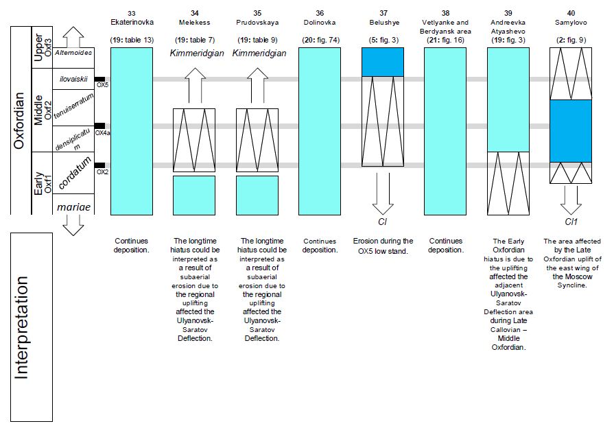
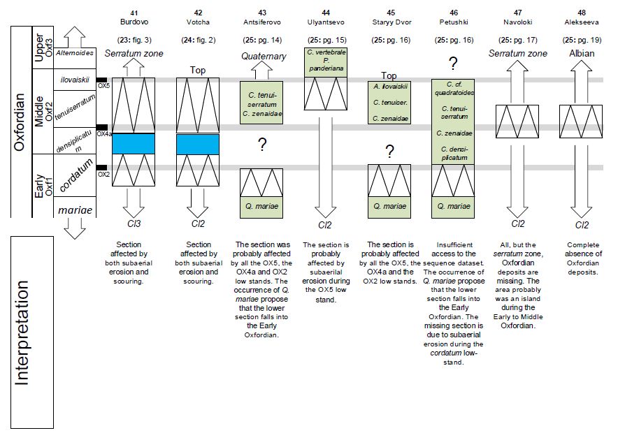
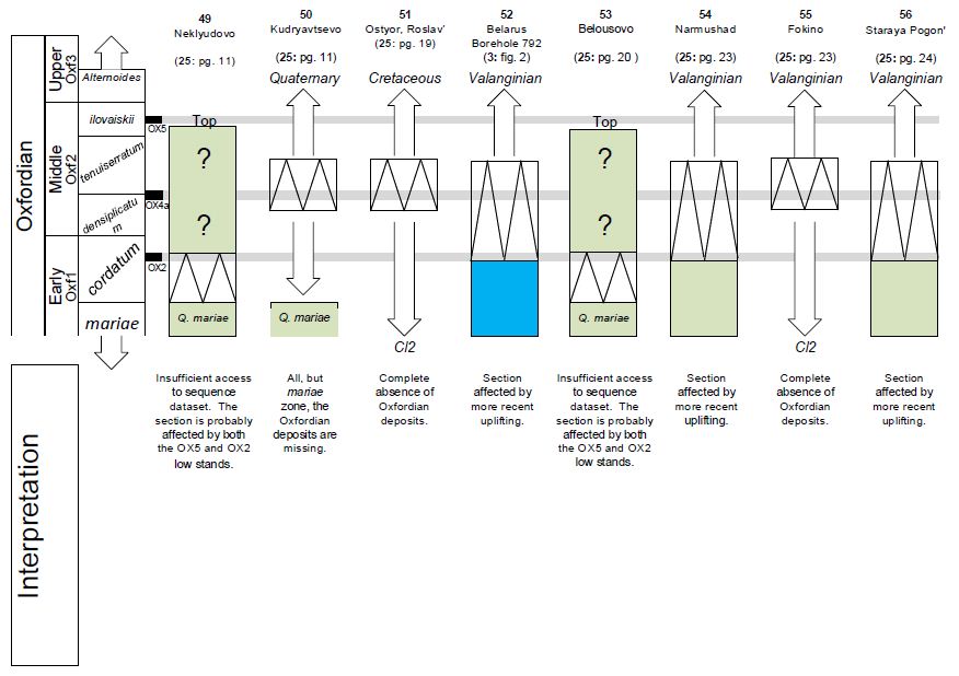
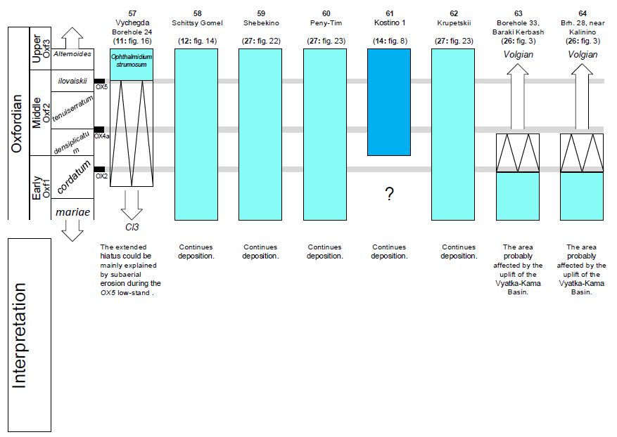
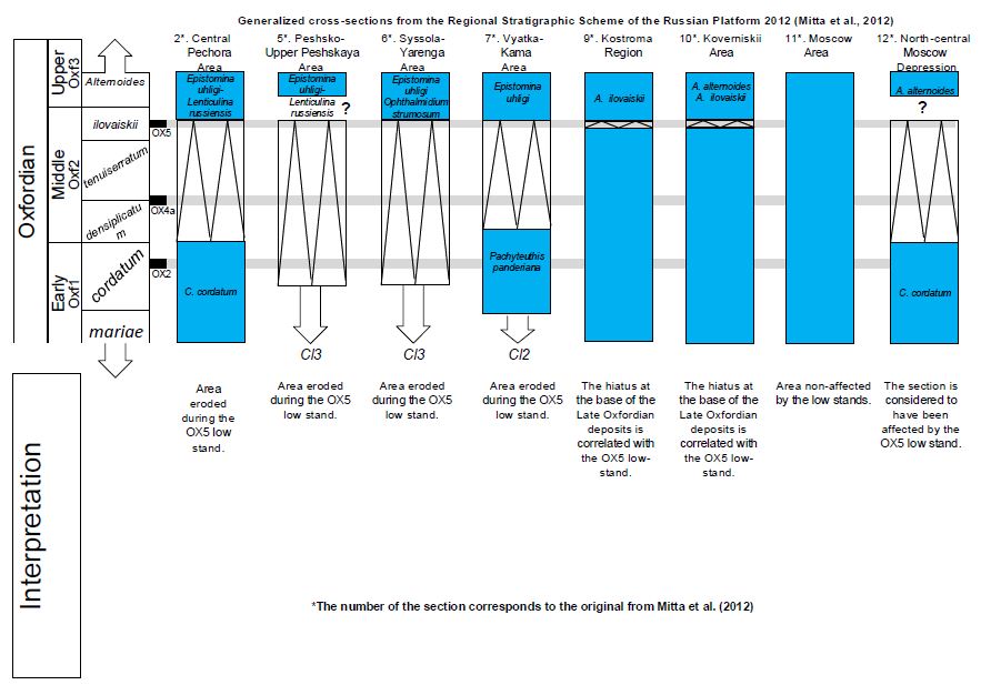
Further investigation of a broader and more widely distributed sample of stratigraphical sections on the Russian Platform has shown that the extended hiatus observed in the Oxfordian could be explained by subaerial erosion during the OX2, OX3, OX4, and OX5 low-stands of the BSP (see Figure 4 and Supplementary Appendix). In fact, there are few available informative cuts in the literature with enough detailed description and/or original depth to be sensitive to sea level fluctuations. The currently available stratigraphical cross-sections can clearly demonstrate, however, that the OX2 and OX5 low-stands correspond to the largest sea level falls that essentially affected the stratigraphy of the Oxfordian Russian Platform (see Figure 4 and Supplementary Appendix). According to the Iloda River section, the OX5 low-stand (falling into the ilovaiskii ammonite biozone) was greater in magnitude than all of the other low-stands, including the OX2 (falling into the late cordatum ammonite biozone). In particular, the OX5 low-stand seems to have led to subaerial conditions, while the OX2 led merely to a shallowing of the sea (Figure 3). The question remains as to whether those observations reflect a regional status of the respective transgressions or are just a picture of local conditions. For example, there are published borehole data from a more southerly location, around the Moscow area, that show the opposite: a subaerial exposure (represented by unconformity or hiatus) around the OX2 and a continuous sequence during the OX5 [42-43] (see also the 1, 2, 4, and 6 cross-sections in the Supplementary Appendix]. However, given the uplifting and subsiding trends in the Moscow Syncline [26] and more regionally during the Late Callovian-Early Oxfordian [27], it is likely that the unconformities in the Moscow area are a result of tectonic activity rather than sea level fall. It seems that the best areas for the study of Oxfordian sea level fluctuation on the Russian Platform are the Pechora Syncline and the East Caspian Depression (Figure 4), which seem to have not been affected by tectonic movements during the Oxfordian. Information extracted from sections from those areas is discussed below. In the east margin of the Caspian Depression, a continuous Jurassic sequence is exposed in the Khan Mountain (River Berdanka) [44]. There, the continuous sedimentation of the yellowish fine sandstone (tenuiserratum biozone) is changed to light gray, fine-grained sandstone (including swallowing markers such as phosphorite nodules) during the earliest ilovaiskii biozone, and then re-changed to a yellowish fine sandstone for the rest of the ilovaiskii biozone (Figure 4 section 1). That specific sector is disrupted by lateral unconformities as well [ref. 44: Figure 13]. This is a clear indication of a shallowing of the basin during the OX5 low-stand as well as evidence that temporally restricts the culmination of the OX5 low-stand during the early ilovaiskii biozone. Both events are congruent with the Iloda River section (Figure 3). In the Pechora Syncline, the picture of the eroded Oxfordian sections could very well be explained by the effects of the BSP (Figure 4). Section 4 in Figure 4 (Borehole no 98, Denisovskaya) can also show that the OX5 was of greater magnitude than the OX2 and the other Oxfordian low-stands. That section, located around the River Pechora in the central Pechora Basin [see also ref. 14: Figure 4] displays an erosional hiatus that extends downwards from the alternoides biozone and up to the cordatum biozone (which is very well represented) and continues further without any break to the mariae biozone and to the Late Callovian. On the east side of the central Pechora Basin, in a section of the River Adzva [ref. 44: Figure 5] (Figure 4: section 5) there is a large hiatus between the alternoides and mariae biozones. Given that the Adzvinskaya area was the eastern border of the margin of the central basin, with a shallower setting eastward, the large hiatus was probably created by the erosional dynamic of the OX5 low-stand, although a lesser contribution of the OX2 cannot be ruled out. Within another section, there is evidence of the occurrence of the OX3 low-stand, which falls into the densiplicatum biozone and seems to be of lesser magnitude than the OX2 and the OX5. That evidence is printed in sections of the River Pizhma [ref. 44: Figure 4] (see Figure 4: section 2 and section 71 in the Supplementary Appendix). There, the light gray limestone of the lower densiplicatum biozone is separated by an unconformity from the gray sandstone of the upper densiplicatum biozone, which includes C. zenaidae ammonites. Lyurov [10] claimed that the upper densiplicatum biozone facies from this section is also present in the Peshskaya Depression on the other side of the Timan Uplift. The excellent correlation between the BSP and the Pechora Syncline stratigraphy continues further into the Middle Jurassic, as can be seen in a more recently published cross-section from the Izhma River [45] (Figure 5: section 0). The section is located in the margin of the Pechora Syncline, probably having an original deposition depth (like the sections of Figure 4) sufficient to be able to reflect with accuracy the changes in sea level. In this detailed cross-section, both the originally proposed chronostratigraphical division and the position of the unconformities are perfectly matched with the T-R cycles of the BSP. The accuracy of the correlation is increased by the fact that the forecast of the BSP, that the Bat2 low-stand is greater in magnitude than the Bat1 (fatter black line in Figure 5), is verified in the Izhma River section by the occurrence of a larger hiatus in the stratigraphy. Finally, the correlation of the BSP with the Izhma River section can prove that the Arctocephalites arcticus biozone corresponds to the Garantiana beds of ref. [46]. By concluding that the BSP was the sea level pattern that affected the Russian Platform, as well as the Oxfordian deposits, one can interpret the complete Middle and Late Jurassic sedimentation on the basis of that pattern. That is the main guide for interpreting the observed sedimentation in the paleogeographical reconstructions of this study.
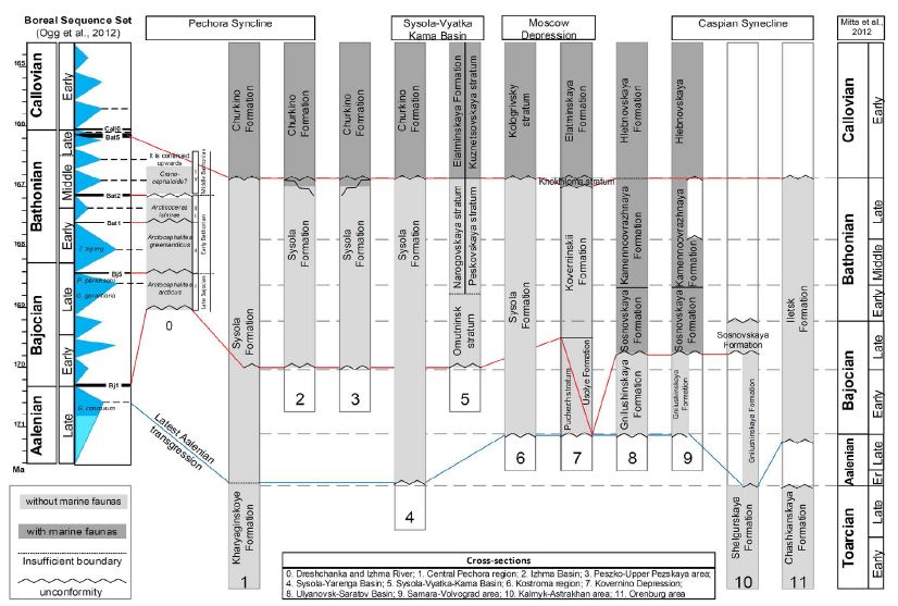
Figure 5: Simplified Middle Jurassic stratigraphy of the Russian Platform from north (left) to south (right). All sections, except section 0, are modified from ref. [18] and are aligned to the original stratigraphical scale (right side). Section 0 is modified from ref. [45]. The light gray sections do not include marine faunas and are therefore not considered to be well aged. Here, the changes of the facies are correlated with major T-R cycles of the BSS (left side) calibrated on the Geologic Time Scale of 2012 [33]. Three major events are highlighted: the latest Aalenian transgression (blue line) and the Early Bajocian and latest Bathonian regressions (red lines). The thickness of the low-stand lines is analogous to the relative magnitude of the events [according to ref. 33].
The Initial Middle Jurassic Exposure of the Middle Russian Sea (MRS)
Apart from the marine Early Permian, the Late Permian, Triassic, and Early Jurassic of the Russian Platform are dominated mainly by continental deposits [22,47]. The MRS was exposed from the Middle Jurassic up to the end of the Early Cretaceous and can be considered as a long epicontinental sea, which was connected to the Tethys (Neotethys) southwards and to the proto-Arctic basins northwards. Southwards, the connection to the Neotethys was reached through the Northern Caucasus, where the Caucasian Sea and the sea straits of the archipelago around the Transcaucasian Arc were exposed [48]. In contrast to the south, where clear marine environments bordered the Russian Platform, the marine basins northwards were not well established in the Early Jurassic. During the Late Triassic-Early Jurassic, the East Barents Sea, to the north of the Russian Platform, was a land mass. In the Late Pliensbachian and the Toarcian, the area transgressed in separate episodes, forming a shallow sea [12,49]. During the Toarcian in particular, the Barents Sea was connected both to the Proto-Canada Basin (Svedrup Basin) and to the North Sea in Europe via the southwestern Barents Sea [49]. At the north part of the West Siberian Basin, the Kara Sea was transgressed by the paleo-Pacific and separated from the Barents Sea by the mountain ranges of Novaya Zemlya [50], but with a communication opening in the southern part of the range [51]. The sea reached as far southwards as the Pechora Basin, north of the Pechora Syncline, while the lake-alluvial Kharyaginskoye Formation was deposited in the Pechora Syncline, within which palynofloras of type I have been recognized [12]. In the outer part of the Pechora Syncline, the Late Toarcian-basal Aalenian foraminifera zones of Astacolus praefoliaceus/Lenticulina multa have been identified [18], while a Toarcian marine transgression is widely recognized in the Arctic Basin [49]. The occurrence of Toarcian sediments in both the Pechora Syncline and the Sysola Basin suggests that during the Toarcian high-stand intervals, the two basins were contemporaneously transgressed from the north (see below). Simultaneously, a large area of the Pricaspian Syncline might have also been transgressed from the south (Figure 6a). The continental deposits that are recognized today in the cross-sections of all those areas are likely due to the initial shallow setting of the basins, which allowed low-salinity environments to form as fresh water from rivers mixed with the weak supply of seawater from the open sea. During the Aalenian, lacustrine-alluvial plains became more widespread, not only in the East Barents Sea, the Pechora Syncline, and the Sysola Basin, but also probably in more areas of the Russian Platform. In all three areas, Aalenian (and possibly Bajocian) deposits have been connected with palynofloras of type II [12]. In the SE Barents Sea, palynofloras of type II have been recognized in boreholes from the Shtokman area and northeasterly. In the Shtokman area, palynofloras of type II have been found together with marine microphytoplankton [12], while in the outer part of the Pechora Syncline, the Aalenian-Early Bajocian foraminifera zone of Trochammina praesquamata has been identified [18]. In the Franz Josef area, Late Aalenian ammonites, bivalves, and foraminifera have been recognized, showing similarities to the bivalve and foraminifera faunas from the Shtokman area. All of that evidence suggests that a shallow sea formed in the East Barents Sea during the Late Aalenian [15]. Furthermore, it suggests that palynofloras of type II are temporally related to a Late Aalenian age. According to the BSP, a major transgression event occurred in the latest Aalenian (Graphoceras concavum, Tethyan ammonite biozone) [33]. That transgression was the first that managed to cross the Russian Platform from south to north. Palynofloras of type II characterize the basal part of the Sysola Formation, which is widely dispersed on the Russian Platform (Figure 5). A few authors believe that the Sysola Formation includes at least two different formations (a lower and an upper part) [e.g., 11,13]; however, there are not well-established physical characteristics separating the formations. Hence, in the most recent Regional Stratigraphic Scheme of the Russian Platform [18], it is referred to as a single formation, although the alternative interpretation is noted [see the notice of Repin, Y.S. in ref. [18]: page 43]. According to Repin et al. [13], the lower part of the Sysola Formation (Vezhay Formation) expresses a Late Aalenian-Bajocian age, while the upper part (Ochey Formation) falls into the Bathonian, although the contemporaneous Dreshchanka Formation (or upper Sysola Formation) in the Pechora Syncline was recently re-aged to the Late Bajocian on the basis of new ammonite findings [45,52,53]. Therefore, a Late Aalenian-Early Bajocian age for the Vezhayskoy stratum and a Late Bajocian-Bathonian age for the Ocheyskoy stratum seems quite reasonable.
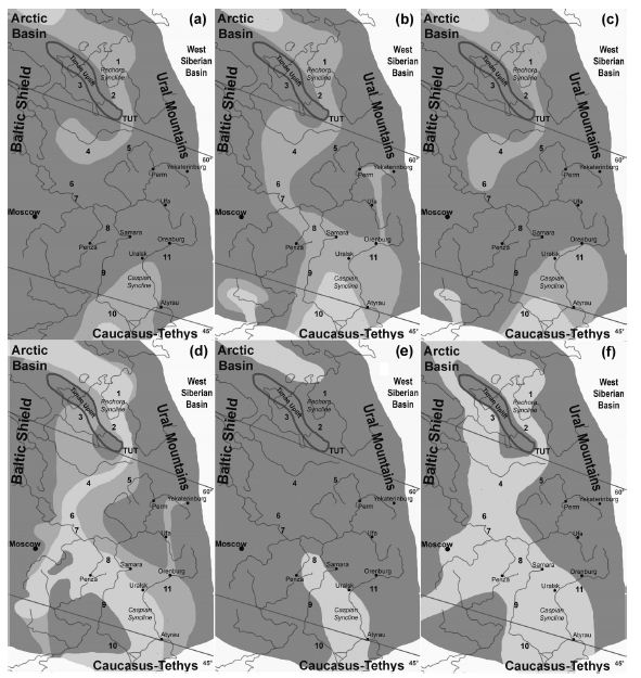
Figure 6: Paleogeographical reconstructions of the early stages of the MRS at: (a) Toarcian (sea level high-stand); (b) latest Aalenian (mid-Graphoceras concavum zone, sea level high-stand, ~170,8 Ma); (c) Early Bajocian (Hyperlioceras discites zone, Bj1 low-stand ~170.2 Ma); (d) latest Bajocian (early Parkinsonia parkinsoni zone, sea level high-stand, 168.6 Ma); (e) Late Bathonian (Clydoniceras discus zone, Bat5 low-stand ~166.2 Ma); (f) Callovian-Oxfordian boundary (OX0 low-stand ~163.5 Ma). Dark gray: land; gray: low-salinity sea; pale gray: shallow sea; white: out of study areas. Paleolatitudes after ref. [74]. Numbers correspond to stratigraphical schemes mentioned in Figure 5.
By interpreting the facies with regard to the sea level fluctuation pattern of the BSP, one can conclude that the Sysola Formation was deposited by two different transgressions: the latest Aalenian and the Late Bajocian-Early Bathonian (Figure 5). Although the absence of marine faunal evidence from the latest Aalenian-Early Bajocian deposits has been interpreted as an indicator of continental origin, the almost singular and widespread exposure of the deposits suggests that they are the product of a single marine transgression: the latest Aalenian transgression (see the Discussion). Indeed, the lower layers (Aalenian-Early Bajocian) of the Sysola Formation deposits have been recognized further southwards from the Pechora Syncline, that is, in the Sysola-Yarenga Basin and the Kostroma Region. In the Unified Stratigraphical Scheme of the Russian Platform [18], the sedimentation in the latter is displayed only up to the Early Bajocian. Those sediments are not well-dated, however, because of the absence of secure marine markers, so here they will be correlated with the latest Aalenian transgression (Graphoceras concavum ammonite biozone). The same interpretation is applied for the lower layers in the Kovernino Depression (Puchezh strata), which are located south of the Kostroma Region and are considered to be of Aalenian-Early Bajocian age [25]. Even southwards in the Ulyanovsk-Saratov basin, Mitta et al. [46] described three more beds (with apparent thickness ~6.5 m) underlying the Late Bajocian beds in a section of the Tarkhanovskaya Pristan site. No ammonites were found within those beds, so an Early Bajocian age has been attributed on the basis of the position of the rocks in the succession. In the description of the section, the lowest bed (bed 1) overlies Upper Permian deposits and is separated by an unconformity from the overlying bed 2. According to the current interpretation, the bed 1 deposits are remnants of either the Toarcian or the latest Aalenian transgression. In the first case, the latest Aalenian transgression should be represented by bed 2, while beds 3 and 4 represent the Late Bajocian transgression of the Garantiana Garantiana and Parkinsonia parkinsoni biozones. Interestingly, a marine clay succession in the Lower Volga region (Large Don Bend; Volgograd region), previously considered to be Late Bajocian (Garantiana zone) in age, was very recently attributed a possible Aalenian-Lower Bajocian age based on the recovery of a diversified belemnite assemblage [54]. According to the most recent Unified Stratigraphical Scheme of the Russian Platform, the latest Aalenian-Bathonian Iletsk Formation has been deposited in the east Caspian Depression (Orenburg region) overlying Early Jurassic continental deposits (Chashkanskaya Formation). In the Kalmyk-Astrakhan area, Aalenian-Early Bajocian sands of the Gnilushkinskaya Formation have been deposited through an unconformity on the Early Jurassic Shelgurskaya Formation and are overlaid, also through an unconformity, by the Late Bajocian Sosnovskaya Formation, in which ammonites have been recognized. Those features are also indications of two different transgressions in the latest Aalenian and the Late Bajocian, which are separated by an Early Bajocian regression period. Even farther south, complete Aalenian marine deposits are known from the Caucasus area [ref. 55 and references therein]. In the northwestern Donets Folded Structures, undivided marine Late Toarcian-Early Aalenian deposits have been recognized, while Late Aalenian deposits are considered eroded, and the Bajocian is represented after a break in the sedimentation [ref. 55 and references therein]. In summary, by the earliest Middle Jurassic, sand deposits are widespread on the Russian Platform, but they are characterized by an absence of marine faunas. Hence, they are currently considered to be of continental origin [e.g., 11]. However, if the sedimentary continuity is interpreted with respect to the BSP, it is possible that behind the widespread occurrence of Early-Middle Jurassic sands is concealed evidence for the initial exposure of the MRS as a whole during the latest Aalenian Graphoceras concavum (Tethyan ammonite biozone) transgression (Figure 6b). The very shallow setting of the young MRS probably prevented the establishment of normal marine salinity, which could explain the phenomenal absence of clear marine faunas (see the Discussion). From a paleogeographical point of view, the absence of Aalenian-Early Bajocian deposits from the Izhma (in the Pechora Syncline), Vyatka-Kama, and Peszko-Upper Pezskaya basins [according to ref. 18] may suggest some fresh ideas about the exact position of the seaway that connected the Lower Vychegda Depression (and the Sysola-Yarenga basins) in the south to the proto-Arctic marine waters in the north. Thus, the absence of sediments of that age from the Peszko-Upper Pezskaya basins suggests that the Lower Vychegda cavity [10] was a positive element and watershed northwards. That view can be further supported by the fact that the same sedimentary absence appears in the Dreshchanka Formation (around the Izhma River area) as a result of the presence of the western margin of the central Pechora Basin on the western side of the Timan Uplift. Thus, the Timan Uplift together with the two basins resulted in a single watershed northward. On the east side of the central Pechora Basin, the Adzvinskaya area formed the eastern border of the central basin. Both areas include the lower layers of the Sysola Formation (of Aalenian-Early Bajocian age); however, southwards of the central Pechora Basin there is no known formation smoothly binding the basin to a shallower relief. That probably means that the sedimentation southwards has been eroded. In such a case, the basin was probably originally opened southwards, allowing communication between the Sysola Basin and the Pechora Syncline through a narrow trough, here referred to as the Timan-Ural Trough (TUT; see Figure 2b). The TUT resulted in the southeast end of the Timan Uplift and was kept even in the Oxfordian, as it is shown in the paleogeographical reconstructions of this study. Repin et al. [13] supposed that the trough opened by subduction during the Bathonian; however, here the trough is considered as originally opened at least since the Toarcian, allowing the Toarcian transgression to form a low-salinity sea, which very probably reached up to the Sysola Basin (Figure 6a). The deposits of the TUT, if not non-existent, should be very rare. In fact, many paleogeographers have hypothesized that such a trough existed, but Jurassic stratigraphical remains from such a trough have never been found. The reason for that may be the narrow setting of the trough, which precluded deposition and/or created conditions for erosional paleocurrents. Alternatively, the area might have eroded in more recent times. In any case, the absence of faunal provincialism between the Pechora Syncline and the areas southwards is evidence for the absence of barriers between those areas [10]. Therefore, the TUT hypothesis may be able to explain all of the observed stratigraphical and biostratigraphical evidence without the need for a more complex paleogeographical scenario. Because of the shallowness of the initial basins and straits, the south-north connection should have been interrupted during the BJ1 regression event, during which enhanced freshwater flow might have further reduced the salinity of the remaining flooded areas. Indeed, the Early Bajocian was a regressive period, as evidenced by well represented sequences in the Caspian Depression [8]. During that period, the previous depositions would have been eroded and the young MRS interrupted (Figure 6c). It seems reasonable to conclude that unconformities between the Gnilushkinskaya and the Sosnovskaya formations in the Ulyanovsk-Saratov basin and the Caspian Syncline, as well as between the Puchezh stratum and the Usolye Formation in the Kovernino Depression (Figure 5), are due to that interruption.
Following the rhythm of the BSP, the next major transgression should appear in the Late Bajocian (during the Garantiana Garantiana and Parkinsonia parkinsoni Tethyan ammonite biozones). Indeed, the early seaway crossing the Russian Platform is currently considered to have been exposed during that time, in particular, during the Garantiana Garantiana ammonite zone, and to have achieved its maximum transgression during the overlaying Parkinsonia parkinsoni zone. Mitta et al. [46] proposed the term Garantiana beds for the ammonite beds placed immediately below the michalskii zone (Russian Platform zonation) and tentatively correlated them with the Garantiana Garantiana zone in the Bajocian zonation established for the Sub-Mediterranean region. According to Mitta et al. [46], those beds correspond to the oldest Jurassic beds of the Russian Platform, which reliably yield ammonites. Therefore, the northernmost proven point where Late Bajocian Tethyan ammonites penetrated the Russian Platform is the Tarkhanovskaya Pristan site in the Ulyanovsk-Saratov basin [46]. On the other hand, the southernmost proven point where Boreal ammonites (Arctocephalites arcticus) penetrated the Russian Platform from the north during the Late Bajocian is in the Pechora River basin north of Ukhta city [45,52]. Until very recently, there was no evidence that the two basins were connected during the Garantiana Garantiana age. The first good evidence for the fusion of the Boreal and Tethyan waters on the Russian Platform came from the latest Bajocian sections (second half of the michalskii zone) of the “Sokur” Quarry near the city of Saratov. There, Boreal taxa seem to have gradually invaded from the north in a basin that was originally inhabited solely by fauna of Tethyan origin [56]. More recent evidence from foraminifera seems to confirm that interconnection [57]. Since the Late Bajocian and during the Bathonian, the Russian Platform basins display a north-to-south stratigraphical continuity, suggesting the exposure of a single water surface, although not all of the basins reached normal marine salinity levels (Figure 6d). However, at the end of the Bathonian, the situation changed. According to the BSP, towards the end of the Bathonian, the Bat5 major regressive event took place, falling into the Clydoniceras discus biozone. It is likely that the Bat5 low-stand was part of an episodic event that also included the OX5; however, its nature is not further considered here. What is important for the current study is that within the Russian Platform, a regional unconformity is observed throughout that interval (Figure 5), suggesting that the MRS should have been interrupted once more (Figure 6e). According to the same data, the regressed areas were flooded again sometime in the latest Bathonian. In the Kovernino Depression, in particular, the small transgression event shown in the BSP between the Bat5 and Call0 low-stands should have led to the Khokhloma stratum (Figure 5: section 7). Furthermore, that transgression might have been greater than what is displayed in the BSP, and it probably resulted in the initiation of the major Callovian transgression in the latest Bathonian, as can be seen at least in the Pechora Basin [see ref. 13: Figure 8].
A wide Callovian sea has been proposed on the basis of observations of the stratigraphy of the Russian Platform. Repin et al. [13] attributed the wide sea to a tectonic subsidence of the TUT area; however, it is likely that a more regional Early-Middle Callovian subsidence was the cause of such a widespread transgression. Furthermore, it seems likely that all main transgression events on the Russian Platform (such as those during the zenaidae and the alternoides stages) are related to an opening through the Mezen Syncline northwards and not to an opening of the TUT, which probably was constantly open during the interval under consideration in this study. By the Middle Callovian, the Moscow Syncline was completely transgressed, allowing a southwesterly marine connection with the Belarus paleobasins. Figure 6f shows another interesting paleogeographical period for the MRS—the Callovian-Oxfordian boundary—a time during which widespread hiatus and uplift appear in the stratigraphy of the Russian Platform (see Figure 2c). In fact, continuous sections can be found everywhere in the Moscow Syncline during that period, suggesting a continuity with the Caspian Syncline and the Caucasus. However, northwards of the Moscow Syncline, a regional hiatus occurs around that interval in the Sysola-Yarenga basins, the Vyatka-Kama Basin, and the Pechora Syncline (Izhma and the central Pechora Basins), with the only exception being the Adzvinskaya area, where the transition is stratigraphically continuous [18]. The Callovian-Oxfordian boundary hiatus is part of a wider Early-Middle Oxfordian hiatus throughout those areas, which is mainly due to the erosional effect of the OX5 low-stand. Therefore, an interruption of the MRS during the Callovian-Oxfordian boundary is not considered possible. There are two more pieces of evidence supporting that view. First, according to the BSP, there is not any certain sea level fall during that interval. Second, the absence of hiatus in the Adzvinskaya area suggests continuous sedimentation, at least in the whole central Pechora Basin, because the former with its shallower depth made up the eastern margin of the latter. That view is congruent with a recently published paleogeographical reconstruction of the area [58].
The Interruption of the Middle Russian Sea in the Oxfordian
The Early Oxfordian was an epoch in which the Russian Platform is thought to have been widely transgressed. The ammonite biozones of mariae and cordatum have been identified in the stratigraphy of many areas (see the Supplementary Appendix); however, they are completely absent from whole territories that are widely believed to have been transgressed during that time. Such areas include the northwestern part of the Voronezh Anticlise (from Kursk northwards, from the Dnepr-Donetsk Depression up to the Moscow Anticline), the area north of the Murom-Lomovskii Deflection, and the Northern Dvina basin (west and south-west of the Timan Uplift). For the northwestern part of the Voronezh Anticlise, Makhnach and Tesakova [59] concluded on the basis of marine faunal exchanges that the Eastern Paleobasin of Belarus was connected to the MRS during the Early Oxfordian, while the NW Voronezh Anticlise uplifted just after that time. In the opinion of Olferiev [28], the NW Voronezh Anticlise was eroded in more recent times, a view which is adopted in the paleaogeographic reconstructions of the current study. For the area north of the Murom-Lomovskii Deflection, Chepikov [60] concluded that the Early Oxfordian deposits north of the city of Vyksa had been completely scoured sometime before the Valanginian. Here, parts of that area are considered to have been subaerially eroded during the strongest low-stands. Regarding the Northern Dvina basin, Lyurov [10] considered both the subaerial erosion that took place during the late cordatum low-stand and the scouring by subsequent transgressions to be the reasons for the observed hiatus in the Early Oxfordian. The observed pause in sedimentation is continued southwards through a long break (Callovian-Oxfordian) in the sedimentation of the Sysola and Yarenga basins [61]. Although the long hiatus could be explained by subaerial erosion during the OX5 low-stand, in the current paleogeographical reconstruction, the MRS is connected northwards only through the Pechora Syncline west of the Timan Uplift (Figure 7a). Such a scenario is compatible with the recent paleogeographical reconstructions of ref. [14,58]. During the OX2 sea level low-stand of the BSP (late cordatum zone on the Russian Platform), hiatuses and unconformities are widespread as a result of sedimentation pause and subaerial erosion. However, in the most informative sections of the Moscow Syncline do not display any abrupt change in the facies before and during the low-stand, suggesting that the marine communication with the adjacent basins (at least with the Dnepr-Donetsk Depression to the south-west and the Caspian Depression to the south-east) was not influenced. Signals of anoxic conditions and eutrophication such as those observed in the OX5 low-stand are also absent. Consequently, an uninterrupted MRS is displayed in Figure 7b.
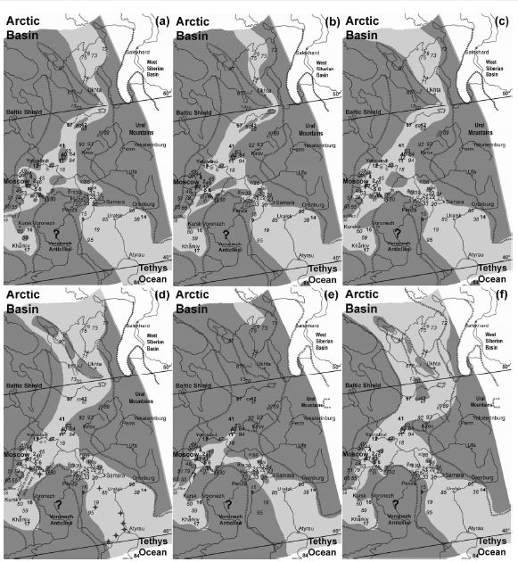
Figure 7: Oxfordian paleogeographical reconstructions of the MRS at: (a) the early cordatum ammonite zone (sea level high-stand), (b) the late cordatum ammonite zone (OX2 sea level low-stand), (c) the middle densiplicatum ammonite zone (OX3 sea level low-stand), (d) the early tenuiserratum ammonite zone (sea level high-stand), (e) the earliest alternoides (ilovaiskii) ammonite zone (OX5 sea level low-stand), and (f) the late alternoides ammonite zone (earliest Late Oxfordian sea level high-stand). The maps are built on the paleogeographical reconstructions of Sasonova and Sasonov [8]. Dark gray: land; pale gray: shallow sea; white: out of study areas; dotted lines: sea-land boundaries in the reconstructions [8]. Numbers correspond to stratigraphical schemes mentioned in Supplementary Appendix. Oxfordian paleolatitudes after ref. [78], oriented to modern latitude coordinates (the original maps of Sasonova and Sasonov [8] are not oriented to the north).
The thickness of Middle Oxfordian sedimentation in section 57 (Vychegda; about 3.5 meters) in comparison with the much lesser thickness of the relicts in sections 42, 68, and 69 (see Supplementary Appendix) suggests that the main sea corridor passed through the Vychegda area. On the other hand, the thin Middle Oxfordian layer from the Burdovo (section 42) suggests a shallowing of the relief and a restriction of the corridor wideness in that area during the low-stands. The persistence of Middle Oxfordian layers in all of the sections are interpreted here as evidence that the connection to the north persisted during the subsequent OX3 low-stand (Figure 7c). The transgressive stages between the OX2 and OX3 low-stands (Figure 3) are not displayed with a specific map. As previously mentioned, the OX3 low-stand was succeeded by a major transgression on the Russian Platform, leading to the invasion of the ammonite Cardioceras zenaidae, together with characteristic Sub-Mediterranean ammonites, from the southwest into the central and northern territories [36-37]. At the same time, there was an exclusively unidirectional (from north to south) Boreal ammonite migration between the central platform and the Northern Caucasus (via the Caspian Depression to the SE) [36]. Therefore, although the northwards migration event should be related to a reduction of the temperature gradient between the Sub-Mediterranean and Boreal basins [36,62], the central-to-southeastwards migration might be explained by a reorganization of the regional paleogeography and a corresponding reorganization of the sea currents [62]. Currents that started from the southwest reached up to the Kostroma area in the north and then turned southeasterly to the Pricaspian Syncline [see ref. 34: Figure 73]. Such a phenomenon could be a combined result of a wider connection northwards and a westerly restriction of the seaway around the west-central MRS (Figure 7d). Such a restriction might be given by the many islands that emerged in the Kostroma area during the Middle Oxfordian [ref. 34: Figures 73-3 & 35]. A wider connection northward, on the other hand, requires the existence of seaways on both sides of the Timan Uplift. That could happen either with a northwards connection, via the Mezen River basin, or with a second penetration of the sea into the Pechora Syncline via fragmentation of the Timan Uplift. The first scenario is supported by the observation of Lyurov [10] that the facies observed in the upper densiplicatum layers in the Pechora Syncline (falling into the zenaidae zone) are also present in the Peshskaya Depression (Belushye area, section 37). Towards the end of the Middle Oxfordian, environmental changes are evidenced in one of the better-represented and well-studied sections of the Russian Platform, the Makar’yev, located in the Kostroma District (very close to section 11 of Figure 7). There, the Ophtalmidium, indicating an oxygen-rich and well-aerated marine environment, progressively give way to planktonic foraminifera (Globuligerina), suggesting a shallowing and restriction of the sea in general [63]. With the restriction of a shallow sea, anoxic and eutrophic conditions would be expected to develop, resulting in characteristic organic-rich deposits such as black shales. Black shales are deposited under euxinian conditions as a result of enhanced weathering and riverine runoff, which promote the development of anoxic conditions [ref. 39 and references therein]. Such carbonaceous shales have been described in layers around the illovaiskii biozone in the southern Kostroma Region [40,64] (see the Discussion). Those features correspond to the OX5 low-stand, during which the evidence previously presented is consistent with the closure of the MRS northwards (Figure 7e). There are specific indications for the restriction of the sea around the central Russian Platform. On the southeast part of the Yaroslav area, the occurrence of islands had essentially restricted the south-north marine communication even in the transgressive zenaidae stage. Thus, a complete closure is expected during the strong OX5 low-stand. To the northwest, the area of the eastern flank of the Moscow Syncline started to uplift during that time [26]. Therefore, a closure of the MRS is expected around that area. The subsequent Late Oxfordian transgression was strong, as indicated by the remains of the alternoides ammonite biozone, which is widespread on the Russian Platform in areas that were previously represented by hiatus (Figure 7f).
Discussion
The Paleogeographic Regime of the Observed Stratigraphical Hiatus
The flat relief of the Russian Platform cratonic block was very sensitive to erosion from even minor vertical tectonic movements and/or sea level fluctuations, resulting in extended unconformities and depositional hiatus within the stratigraphical cross-sections [29]. Moreover, erosion in more recent times has further blurred the paleogeographical reconstructions. In any case, it is believed that the original extension of the sea surface was greater than the extension of the currently preserved Mesozoic deposits because facies generally do not vary near the outcrop edge [29]. The erosional dynamic of transgressions (scouring) is often cited in the Russian literature as a reason for the absence of sedimentation from areas where sedimentation should have existed [e.g., 10,29]. Although that could be a real reason for the absence, its real effect and intensity are difficult to prove. Nevertheless, in some cases, older rocks have been found to be reworked by subsequent transgressions; for example, the rocks of the Callovian islands in the NW Voronezh Anticline are considered to have been eroded by Cretaceous transgressions [65]. In paleogeography, the definition of the exact reason (submarine or subaerial) for observed erosion is fundamental, because it indicates whether the area under study was land or sea during the erosion interval. Scouring from strong paleocurrents is an erosional means for the dissolution of past depositions in deep basins, as, for example, in the southwestern Barents Sea [ref. 66 and references therein] or the submarine Rio Grande Rise-Walvis Ridge between South America and Africa [67]. However, both of those cases involve deep basins with uplifted barriers at the front of the paleocurrents, so they are different from the case of the MRS, which was a shallow sea corridor. A more similar case is that of the Jeanne d’Arc Basin in the Central Atlantic. That shallow basin was a gateway for marine interchange between the North and Central Atlantic just after the termination of a latest Jurassic land bridge. A large part of the Berriasian is missing from the Jeanne d’Arc Basin stratigraphy, which Brikiatis [68] concluded to be the result of erosion by the paleocurrents that initially connected the previously separated Central and North Atlantic [see ref. 68: Supplementary Appendix S2]. The case of the Jeanne d’Arc Basin in the Central Atlantic may be similar to what happened on the Russian Platform. During the low-stands, the width of the MRS was essentially reduced, limiting the extent of the seaway to the deeper parts of the synclines. The shallower areas were subaerially eroded, while paleocurrents in marine basins increased their erosional dynamic and decreased their depositional dynamic. On the other hand, the absence of strong paleocurrents (due to the shallowness) during the very early stages of the MRS corridor could explain the maintenance of low-salinity basins (due to reduced sea water supply), within which marine faunas were unable to survive. However, in such basins, the sedimentation should not have been eroded by paleocurrents, and the sedimentological history should have been better preserved. Such a contrasting picture is exactly what is observed today. For example, in the Sysola Basin, marine Early Oxfordian deposits are absent, but Aalenian-Bathonian deposits are present and have long been considered to be of continental origin because of the absence of marine faunas (see Figures 5 and 6 and the next paragraph). The absence of Early Oxfordian deposits, in particular, from the north-central Russian Platform could be mainly explained by subaerial erosion during the OX5 low-stand (Figure 7). In any case, in a tectonically stable basin, the remains of the original deposition should correspond to the deeper part of the original synclines. That seems to be the case for the Jurassic deposits in the northwest Russian Platform, where the Early Permian deep structures are filled by Jurassic sediments [10] (Figure 2b). Given that subaerial erosion influenced the Russian Platform stratigraphy to some extent during all of the examined Oxfordian low-stand events (see the Supplementary Appendix), there is a question as to which of the low-stands interrupted the north-south unity of the MRS. Taken together, the evidence suggests that the Oxfordian MRS was interrupted only during the OX5 low-stand interval (early illovaiskii biozone). Specifically, the stratigraphical evidence suggests that the magnitude of the sea level fall during the OX5 low-stand exceeded that during the other low-stands. In addition, the OX5 low-stand was exceptional in the amplitude of the positive δ18O excursion recorded in the contemporaneous Tethyan geochemical record (Figure 3), which suggests a possible glacio-eustatic origin (Brikiatis in preparation). Moreover, the deposition of carbon-rich sediments in the non-eroded layers of the illovaiskii biozone suggest that anoxic and eutrophic conditions existed at that time, which would be expected as a result of restriction of a shallow sea due to a sea level fall. Such conditions have been described in layers around the illovaiskii biozone in the southern Kostroma Region where carbonaceous shales have been deposited [40,64]. Consequently, apart from the OX5 low-stand, all of the Oxfordian low-stands (including the OX2) are concluded here to have not been strong enough to interrupt the MRS. In particular, the magnitude of the OX5 is estimated to be on the order of ~50-100 meters, while that of the OX2 and the rest of the Oxfordian low-stands could be on the order of 20-40 meters.
What is the Earliest Age at which the Middle Russian Sea Could Have Been Exposed?
As the SE Barents Sea became deeper and deeper since the Early Jurassic, the sea penetrated into the previously lake-alluvial environments during sea level high-stand periods. However, because of the shallow setting of the basins, normal marine salinity was slow to become established throughout the Russian Platform. Thus, not only the Aalenian but also the Bajocian and Bathonian deposits were characterized by low salinity, which is the reason that, until recently, the Bajocian and Bathonian deposits were thought to be of continental origin. A corresponding example could be considered in the Yenisei-Khatanga Basin, located in the West Siberian Basin. There, the Jurassic sedimentation is started by latest Aalenian deposits (Vymsky Formation). The salinity of the deposits, determined on the basis of the Sr/Ba ratio, indicates a low-salinity marine formation [ref. 69 and references therein]. Marine biota and, in particular, ammonites were unable to inhabit such environments. In restricted basins, when the seawater supply is less than the riverine runoff supply, anoxic conditions develop through haline stratification of the water column [e.g., 70]. Jurassic epicontinental seas are thought to have developed such a stratified depositional environment, with an upper, well-oxygenized chemocline and a lower, anoxic chemocline [71-72]. It is possible that during the Toarcian transgressions, a low-salinity sea reached up to the Pechora Syncline (Kharyaginskoye Formation) and, probably, up to the Sysola-Yarenga Basin, where Toarcian deposits were recently recognized. However, that is probably the southern limit of the low-salinity sea, because there is no stratigraphical evidence southwards. On the other hand, Aalenian-related deposits are more widespread and almost continuous on the whole Russian Platform (Figure 5). By itself, the fact that Aalenian (or likely Aalenian) deposition was the only widespread and contemporaneous sedimentation event on the Russian Platform since the Permian could be evidence of a single marine transgression. Otherwise, if the known Aalenian deposits were scarce continental deposits, then why is there no example of analogous sedimentation from the Triassic?. The recognized Late Aalenian palynofloras of type II within the likely Aalenian deposits suggest that the stratigraphical remains of the Early-Middle Jurassic deposits on the Russian Platform are a result of a latest Aalenian transgression (Graphoceras concavum biozone). That transgression managed to flood the Russian Platform for the first time, forming a single water surface, from north to south, albeit of low salinity. Such a semi-marine corridor was a barrier to both marine (from north to south) and terrestrial (from east to west) biota. According to the most updated chronostratigraphical chart of ref. [33], this event corresponds to 171 Ma (Figure 5).
Online Supplementary Materials
Supplementary Appendix: Stratigraphic cross-sections used in the Oxfordian paleogeographical reconstructions.
References
- Stampfli GM, Borel GD (2002) A plate tectonic model for the Paleozoic and Mesozoic constrained by dynamic plate boundaries and restored synthetic oceanic isochrones. Earth and Planetary Science Letters 196: 17-33.
- Cocks LRM, Torsvik TH (2006) European geography in a global context from the Vendian to the end of the Palaeozoic, ln: Gee DG, Stephenson RA (eds) European Lithosphere Dynamics. Geological Society, London, Memoirs 32, pg: 83-95.
- Wegener A (1915) Die Entstehung der Kontinente und Ozeane. Sammlung Vieweg, Heft 23, Braunschweig. [in German]
- Jordan SMR, Barraclough TG, Rosindell J (2016) Quantifying the effects of the break up of Pangaea on global terrestrial diversification with neutral theory. Philosophical Transactions Royal Society B 371, 20150221.
- Smith PL (1983) The Pliensbachian ammonite Dayiceras dayiceroides and Early Jurassic paleogeography. Canadian Journal of Earth Sciences 20: 86-91.
- Brikiatis L (2017) A re-evaluation of the basal age in the DSDP hole at Site 534. GeoResJ 14: 59-66.
- Westermann GEG (1993) Global bio-events in mid-Jurassic ammonites controlled by seaways, ln: House MR (ed), The Ammonoidea: environment, ecology, and evolutionary change. Systematics Association Special Volume Series pg: 47: 187-226. Clarendon Press, Oxford.
- Sasonova IG, Sasonov NT (1967) Paleogeography of the Russian Platform during the Jurassic and Early Cretaceous time // Trans. VNIGRI. Vol.62. Leningrad: Nedra. 260 p. [in Russian]
- Vereshchagin VN, Ronov AB (1968) Volume III, Triassic, Jurassic and Cretaceous, in: Vinogradov AP (Ed), Atlas of the lithological-paleogeographical maps of the USSR. Academy of Sciences of the USSR, Moscow. [in Russian]
- Lyurov SV (1996) Jurassic deposits of the north of Russian Plate. Uralian Branch of Russian Academy of Science, Ekaterinburgh. [in Russian]
- Dedeyev VA, Mukhin VA, Rozanov SI (1997) Jurassic sandy strata of the European North Russia, 1997. Institute of Geology of Komi Science Centre, Ural Branch of Russian Academy of Sciences, Syktyvkar. [in Russian]
- Chirva SA (1999) To paleogeography of the northeast Russian platform and Barents Sea during the Early – Middle Jurassic time, in: Problems of the Mesozoic stratigraphy and paleontology. Lecturing in memory of M.S. Mesezhnikov, pp. 55-62. VSEGEI, Saint-Petersburg. [in Russian]
- Repin Yu S, Zakhaгov VA, Meledina SV, Nalnyaeva TI (2006) Atlas of the mollusks of the Pechora Jurassic. Bulletin of VNIGRI 3. Nedгa, St. Petersburg. [in Russian]
- Repin Yu.S, Bystrova VV, Sarkisova EV (2010) Oxfordian of the Timan-Pechora province. Petroleum Geology-Theoretical and Applied Studies 5.
- Zakharov VA, Mesezhnikov MS, Ronkin Z, et al. (1983) Paleogeography of the North USSR in the Jurassic period. Nauka, Novosibirsk.
- Miller KG, Mountain GS, Wright JD, Browning JV (2011) A 180-million-year record of sea level and ice volume variations from continental margin and deep-sea isotopic records. Oceanography 24: 40-53.
- Shennan I, Long AJ, Horton BP (2015) Handbook of Sea-Level Research. John Wiley & Sons, Ltd, West Sussex.
- Mitta VV, Alekseev AS, Shik SM, et al. (2012) Unified regional stratigraphic scheme of the Jurassic of East European Platform. Explanatory note. VNIGNI, Moscow. [in Russian]
- Ziegler PA (1989) Evolution of Laurussia: A Study in Late Palaeozoic Plate Tectonics. Springer, Netherlands.
- Torsvik TH, Smethurst MA, Meert JG, Van der Voo R, McKerrow WS, et al. (1996) Continental break-up and collision in the Neoproterozoic and Palaeozoic – A tale of Baltica and Laurentia. Earth-Science Reviews 40: 229-258.
- Puchkov V N (1997) Structure and geodynamics of the Uralian orogeny. Geological Society, London, Special Publications 121: 201-236.
- Grachev AF, Nikolaev VA, Nikolaev VG (2006) East European platform development in the Late Precambrian and Paleozoic: structure and sedimentation. Russian Journal of Earth Sciences 8: ES4001.
- Brikiatis L (2020) An early Pangaean vicariance model for synapsid evolution. Scientific Reports 10.
- Barents Shelf plate (1988) Proceedings of the PGO “Sevmorgeologiya” 196. Nedra, Leningrad. [in Russian]
- Masaitis VL, Naumov MV, Maschac MS, Slastenov JL (2009) New data on Jurassic stratigraphy of Kavernino depression, ln: Zakharov VA (ed), Jurassic system of Russia: problems of stratigraphy and paleogeography. Third all-russian meeting. Nauka, Saratov, pg: 140-141.
- Zorina SO (2007) Eustatic and geodynamic features of formation of Middle-Upper Jurassic Deposits in the East Russian Plate, in: Zakharov VA (ed) Jurassic System of Russia: problems of stratigraphy and paleogeography. Second all-Russian meeting, pg: 87-89. Yaroslavl State Pedagogical University, Yaroslavl. [in Russian].
- Zorina SO (2012) Middle Jurassic-Lower Cretaceous tectonic-eustatic cycles of the Southern East European Craton. Doklady Earth Sciences 444: 702-705.
- Olferiev AG (2007) The Geological history of Voronezh Anticlise in Jurassic period, in: Zakharov VA (ed) Jurassic System of Russia: problems of stratigraphy and paleogeography. Second all-Russian meeting, pg: 181-183. Yaroslavl State Pedagogical University, Yaroslavl. [in Russian].
- Sahagian D, Pinous O, Olferiev A, Zakharov V (1996) Eustatic Curve for the Middle Jurassic-Cretaceous Based on Russian Platform and Siberian Stratigraphy: Zonal Resolution. American Association of Petroleum Geologists Bulletin 80: 1433-1458.
- Haq BU, Hardenbol J, Vail PR, et al. (1988) Mesozoic and Cenozoic chronostratigraphy and cycles of sea-level change, in: Wilgus CK, Hastings,BS, Kendall CGSC, Posamentier HW, Ross CA, Van Wagoner JC (Eds), Sea level changes-an integrated approach. SEPM Special Publication 42: 71-108.
- Beisel AL, Alifirov AS (2011) Coincidences of the Callovian and Upper Jurassic event levels in Moscow Syneclise and Exxon’s sequence chart: possible interpretation, in: Zakharov VA, Rogov MA, Ippolitov AP (eds), Jurassic System of Russia: problems of stratigraphy and рaleogeography. Fourth All-Russian meeting. LEMA, St. Petersburg. [in Russian].
- Hardenbol J, Thierry J, Farley MB, Jacquin Th, de Graciansky P-C, Vail PR, et al. (1998) Mesozoic and Cenozoic sequence chronostratigraphic framework of European basins, in: de Graciansky P-C, Hardenbol J, Jacquin Th, Vail PR (eds), Mesozoic-Cenozoic Sequence Stratigraphy of European Basins. Society for Sedimentary Geology Special Publication 60, pg: 3-13 and 763-781.
- Ogg JG, Hinnov LA (2012) Chapter 26: Jurassic, in: Gradstein, F.M., Ogg, J.G., Schmitz, M.D., Ogg, G.M. (eds.), The Geologic Time Scale 2012. Elsevier, Amsterdam, pg: 731-791.
- Kiselev DN, et al. (2012) Objects of the archaeological heritage in Yaroslavl region: stratigraphy, paleontology, and paleography. Yustitsinform, Moscow.
- Baranov VN (1971) On the history of Middle Jurassic seas in the Upper Volga region. Geology and Paleontology, Moscow State Pedagogical Institute 87: 49-63. [in Russian]
- Rogov MA (2002) Ways of migrations and correlative potential of the Middle Oxfordian ammonites: new data from the Russian plate. Proceedings of the International Conference Paleobiogeography and Paleoecology 2001. Geobios, Mémoire spécial 24: 181-182.
- Rogov M, Zakharov V, Kiselev D (2008) Molluscan immigrations via biogeographical ecotone of the Middle Russian Sea during the Jurassic. Volumina Jurassica 6: 143-152.
- Louis-Schmid B, Rais P, Bernasconi SM, Pellenard P, Collin P-Y, Weissert H (2007) Detailed record of the mid-Oxfordian (Late Jurassic) positive carbon-isotope excursion in two hemipelagic sections (France and Switzerland): A plate tectonic trigger?. Palaeogeography, Palaeoclimatology, Palaeoecology 248: 459-472.
- Brikiatis L (2019) Arido-eustasy: A new example of non-glacial eustatic sea level change. Gondwana Research 70: 25-35.
- Zakharov VA, Rogov MA, Shchepetova ЕV (2017) Black shale events in the Late Jurassic – earliest Cretaceous of Central Russia, in: Zakharov V.A., Rogov M.A., Shchepetova E.V. (eds), Jurassic system of Russia: problems of stratigraphy and paleogeography. Seventh all-russian meeting. Moscow, pg: 57-63.
- Hallam A, Bradshaw MJ (1979) Bituminous shales and oolitic ironstones as indicators of transgressions and regressions. Journal of the Geological Society 136: 157-164.
- Olferiev AG (2001) On Middle-Upper Oxfordian boundary in the East European Platform. Stratigraphy and Geological Correlation 9: 69-76. [in Russian]
- Ustinova MA (2009) The distribution of calcareous nannofossils and foraminifers in the Callovian, Oxfordian, and Volgian deposits in the southwest of Moscow. Stratigraphy and Geological Correlation 17: 204-217.
- Mesezhnikov MS (1989) The Middle and Upper Oxfordian of the Russian Platform. Transactions of the Interdepartmental Stratigraphic Committee of the USSR 19. Nauka, Leningrad. [in Russian]
- Mitta VV, Kostyleva VV, Glinsky LA (2013) On the Bajocian and Bathonian (Middle Jurassic) of the Izhma River basin. Problems of Geology of the European Russia: a collection of scientific works. Saratov State Technical University, Saratov, pg: 93-103. [in Russian]
- Mitta VV, Kostyleva VV, Glinskikh LA, Shurygin BN, Starodubtseva IA (2014). Middle Jurassic stratigraphy in the southwestern part of the Republic of Tatarstan. Stratigraphy and Geological Correlation 22: 28-43.
- Crasquin-Soleau S (2003) Middle and Late Permian stratigraphic correlations on the Russian Platform: significance of ostracodes. Revue de Micropaléontologie 46: 23-33.
- Ruban DA (2006) The palaeogeographic outlines of the Caucasus in the Jurassic: the Caucasian Sea and the Neotethys Ocean. Annales Géologiques de la Péninsule Balkanique 67: 1-11.
- Nikitenko B, Shurygin B, Mickey MB (2008) High resolution stratigraphy of the Lower Jurassic and Aalenian of Arctic regions as the basis for detailed palaeobiogeographic reconstructions. Norwegian Journal of Geology 88: 267-278.
- Smelror M, Petrov OV, Larssen GB, Werner S (2009) Atlas-Geological history of the Barents Sea. Geological Survey of Norway, Trondheim.
- Kontorovich AE, Kontorovich VA, Ryzhkova SV, Shurygin BN, Vakulenko LG, et al. (2014) Jurassic paleogeography of the West Siberian sedimentary basin. Russian Geology and Geophysics 54: 747-779.
- Mitta VV (2009) The upper Bajocian-Lower Bathonian of Pechora River basin and Boreal-Tethyan correlation. Stratigraphy and Geological Correlation 17: 68-78.
- Mitta V, Glinskikh L, Kostyleva V, Dzyuba O, Shurygin B, Nikitenko B (2015) Biostratigraphy and sedimentary settings of the Bajocian-Bathonian beds of the Izhma River basin (European North of Russia). Neues Jahrbuch für Geologie und Paläontologie – Abhandlungen 277/3: 307-335.
- Ippolitov AP (2017) Discovery of marine Aalenian?‒Lower Bajocian strata in the Volga region, in: Zakharov VA, Rogov MA, Shchepetova EV (eds), Jurassic system of Russia: problems of stratigraphy and paleogeography. Seventh all-russian meeting. Moscow, ppg: 69-73.
- Kalacheva ED (1988) Aalenian, in: Krymholts, G. Ya., Mesezhnikov, M.S., Westermann, G.E.G. (Eds) The Jurassic Ammonite Zones of the Soviet Union. GSA Special Papers 223: 19-23.
- Mitta V, Kostyleva V, Dzyuba O, Glinskikh L, Shurygin B, et al. (2014). Biostratigraphy and sedimentary settings of the Upper Bajocian-Lower Bathonian in the vicinity of Saratov (Central Russia). Neues Jahrbuch für Geologie und Paläontologie – Abhandlungen Band 271: 95-121.
- Glinskikh LA, Nikitenko BL (2015) Foraminiferal zone Trochammina aff. praesquamata (Middle Jurassic) as interregional correlation level (Siberia – Russian Platform). Interexpo Geo-Siberia 2: 28-32. [in Russian].
- Repin Yu.S., Bystrova VV (2014) Callovian and Oxfordian boundary in the Timan-Pechora Province. Petroleum Geology-Theoretical and Applied Studies 9, (3).
- Makhnach VV, Tesakova EM (2015) Palaeogeographic Reconstructions of the Natural Environment in Southeast Belarus during the Bathonian-Oxfordian Ages. Moscow University Geology Bulletin 70: 159-170.
- Chepikov CR (1967) Geology of the U.S.S.R. Vol. XI, The Volga and Kama Regions. Nedra, Moscow.
- Chirva SA, Mesezhnikov MS, Yakovleva SP (1988) Upper Jurassic deposits of Sysola and Yarenga oli-shale fields of the Russian Platform. Proceedings of Academy of Science of USSR, Geology Series 4: 38-50. [in Russian].
- Kiselev DN (2004) The thermal regime dynamics in Callovian-Oxfordian seas of Northwestern Eurasia: implications off relative paleotemperature data. Stratigraphy and Geological Correlation 12: 347-366.
- Colpaert C, Nikitenko BL, Hafaeva SN (2015) Late Callovian-Early Kimmeridgian foraminiferal assemblages (Makar’yev section, Russian Platform) and paleoecological reconstruction, in: Vishnevskaya VS, Olshanetsky DM (eds) Modern micropaleontology, Proceedings in the XVI All-Russian micropaleontological meeting. Kaliningrad, pg: 221-225. [in Russian]
- Bushnev DA, Shchepetova EV, Lyyurov SV (2006) Organic geochemistry of Oxfordian carbon-rich sedimentary rocks of the Russian plate. Lithology and Mineral Resources 41: 423-434.
- Gerasimov PA, Mitta VV, Kochanova MD, Tesakova EM (1996) The Callovian fossils of the Central Russia. VNIGNI, Moscow. [in Russian]
- Brikiatis L (2014) The De Geer, Thulean and Beringia routes: key concepts for understanding early Cenozoic Journal of Biogeography 41: 1036-1054.
- Kucera M, Malmgren BA, Sturesson U (1997) Foraminiferal dissolution at shallow depths of the Walvis Ridge and Rio Grande Rise during the latest Cretaceous: inferences for deep-water circulation in the South Atlantic. Palaeogeography Palaeoclimatology Palaeoecology 129: 195-212.
- Brikiatis L (2016) Late Mesozoic North Atlantic land bridges. Earth-Science Reviews 159: 47-57.
- Zamirailova A, Zanin Yu, Eder V (2013) The composition and lithogeochemical characteristics of the Middle Jurassic of the Yenisei‐Khatanga basin, in: Zakharov VA (ed) Jurassic System of Russia: Problems of stratigraphy and рaleogeography. Fifth All‐Russian meeting. Izdat Nauka Servis, Yekaterinburg, pg: 80-82. [in Russian]
- McArthur JM, Algeo TJ, van de Schootbrugge B, Li Q, Howarth RJ (2008) Basinal restriction, black shales, Re-Os dating, and the Early Toarcian (Jurassic) oceanic anoxic event. Paleoceanography 23.
- Küspert W (1982) Environmental changes during oil shale deposition as deduced from stable isotope ratios, in: Einsele G, Seilacher A (eds), Cyclic and Event Stratification. Springer, Heidelberg, pg: 482-501.
- Schouten S, van Kaam-Peters HME, Rijpstra WIC, Schoell M, Sinninghe-Damste JS (2000) Effects of an Oceanic Anoxic Event on the stable carbon isotopic composition of early Toarcian carbon. American Journal of Scince 300: 1-22.
- Deep Time Maps (2020) Global Paleogeography: Late Jurassic. Web accessed 18 July 2021.
- Scotese CR (2014) Technical report: Atlas of Jurassic Paleogeographic Maps, PALEOMAP Atlas for ArcGIS, volume 3, The Jurassic and Triassic, Maps 32 – 42, Mollweide Projection, PALEOMAP Project, Evanston, IL.
- Gordenko NV (2008) Middle Jurassic Flora of the Peski Locality (Moscow Region): Systematics, Paleoecology, and Phytogeography. Paleontological Journal 42: 1285-1382.
- Zorina SO (2014) Sedimentation regime and accommodation space in the Middle Jurassic- Lower Cretaceous on the eastern Russian Plate. Russian Geology and Geophysics 55: 1195-1204.
- Wierzbowski H, Rogov MA, Matyja BA, Kiselev D, Ippolitov A (2013) Middle Upper Jurassic (Upper Callovian-Lower Kimmeridgian) stable isotope and elemental records of the Russian Platform: Indices of oceanographic and climatic changes. Global and Planetary Change 107: 196-212.
- Wierzbowski H, Rogov M (2011) Reconstructing the palaeoenvironment of the Middle Russian Sea during the Middle-Late Jurassic transition using stable isotope ratios of cephalopod shells and variations in faunal assemblages. Palaeogeography, Palaeoclimatology, Palaeoecology 299: 250-264.
