Abstract
Barite–galena mineralization constitutes an important component of Nigeria’s industrial mineral and base metal resource potential. This study presents an integrated geophysical investigation of structurally controlled mineralization within the Precambrian basement terrain of Iyamitet, Obubra Local Government Area, south-eastern Nigeria. This deployment of ground magnetic and Very Low Frequency Electromagnetic (VLF-EM) methods produced robust interpretation of concise data for delineating Barite–Galena mineralisation within the Iyamitet area. Residual Magnetic Intensity, Analytical Signal, 3-D Euler Solution, and Q-Factor maps were generated to identify conductive sulphide-bearing structures, lithological contacts, hydrothermal alteration zones, and fracture-controlled mineralized pathways. The magnetic maps revealed pronounced low magnetic anomalies associated with hydrothermal alteration and sulphide mineralisation, while the Analytical Signal and Euler Solution maps delineated dominant NE–SW and NW–SE structural trends interpreted as faults, fractures, and vein systems favourable for hydrothermal fluid migration and ore emplacement. The Q-Factor map derived from VLF-EM filtering revealed conductive linear anomalies corresponding to sulphide-rich fracture zones spatially associated with magnetic lows and clustered Euler depth solutions. The mineralisation potential zonation further identified moderate to high prospective zones characterized by structurally controlled conductive and resistive signatures indicative of hydrothermal Pb–Zn–Barite mineralisation. The continuity and spatial distribution of these anomalies suggest significant economic potential for Barite–Galena deposit development within the area.
The integrated interpretation confirms that the Iyamitet area is highly prospective for structurally controlled hydrothermal Barite–Galena mineralisation. The results demonstrate the effectiveness of integrated geophysical techniques for mineral exploration in structurally complex basement terrains and provide a scientific framework for targeted drilling and sustainable mineral resource development in southeastern Nigeria.
Keywords
Barite–galena, Basement mineralization, Magnetic survey, VLF-EM, Structural controls, Nigeria
Introduction
Barite (BaSO₄) is a high-density industrial mineral widely used in petroleum drilling, chemical industries, and radiation shielding applications, while galena (PbS) remains the principal ore of lead globally. In Nigeria, barite–galena mineralization is commonly associated with hydrothermal vein systems controlled by tectonic structures within basement and sedimentary terrains. Oladapo et al. (2011) [1], Ezekwesili et al. (2012) [2] and Obaje et al. (2009) [3], the aforementioned carried out related studies on Galena and Barite deposit in different location within Nigeria. The workdone by Akinde et al. 2019 [4] recommended the use of multiple geophysical techniques to uncover the presence of Barite – Galena Mineralisation since the results of Vertical Electrical Sounding alone could not properly delineate the presence of Barite-Galena mineralisation. Recently, Akinde et al 2026b [5] adopted magnetotelluric to delineate structural traps hosting groundwater bodies, the work focussed on the important roles played by structural traps which is also relevant in hydrothermal mineral flows. Despite early documentation of barite occurrences, many deposits remain poorly characterized geophysically, limiting effective exploration and resource development. In the Iyamitet area, artisanal mining has revealed occurrences of barite–galena assemblages within quartz-schist host rocks. This study thus integrates the deployment of ground magnetic and Very Low Frequency VLF geophysical methods to characterize structural controls, delineate mineralized zones, and evaluate Iyamitet’s Barite-Galena mineralistion deposit (Figures 1 and 2).
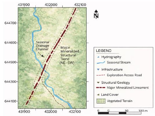
Figure 1: Geological Exploration Base Map of the Iyamitet Prospect Area Showing Hydrographic Network, Exploration Access Routes, Vegetated Terrain and Dominant NE-SW Trending Mineralised Structural Lineament Interpreted to Control Subsurface Mineralisation.
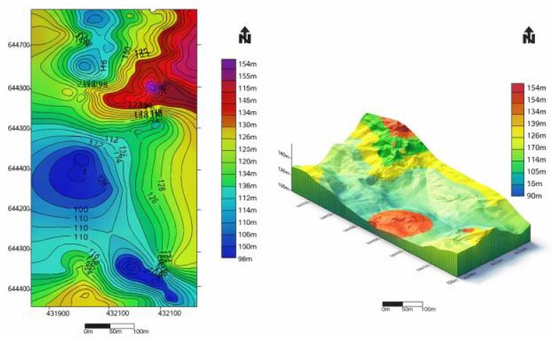
Figure 2: Elevation and 3-D Elevation Map of the Study Area.
Geological Setting
The study area lies within the southeastern Nigerian Precambrian basement complex, comprising schists, phyllites, gneisses, and granitic intrusions. Regionally, the Oban Massif forms part of a tectonically reworked crustal block influenced by Pan-African orogeny. Hydrothermal mineralization is structurally controlled and typically occurs along fracture-filling systems within metamorphic lithologies. Oden et al. (2012) [6] carried out comparative analysis of fracture lineaments in Oban and Obudu areas, SE Nigeria.
Materials and Methods
Magnetic Survey
Ground magnetic data were collected along 21 traverses with 20 m station spacing. Data enhancement techniques included:
- Reduction to magnetic equator (RTE).
- Upward continuation filtering.
- Pseudo-gravity transformation.
- Analytical signal analysis.
- Spectral depth estimation.
- 3-D Euler deconvolution.
Electromagnetic Survey
VLF-EM data were acquired using ABEM WADI equipment along established grid lines. Filtered real (Q-factor) anomalies were used to map conductive structures interpreted as fracture systems associated with mineralization (Figures 3.1-3.3).
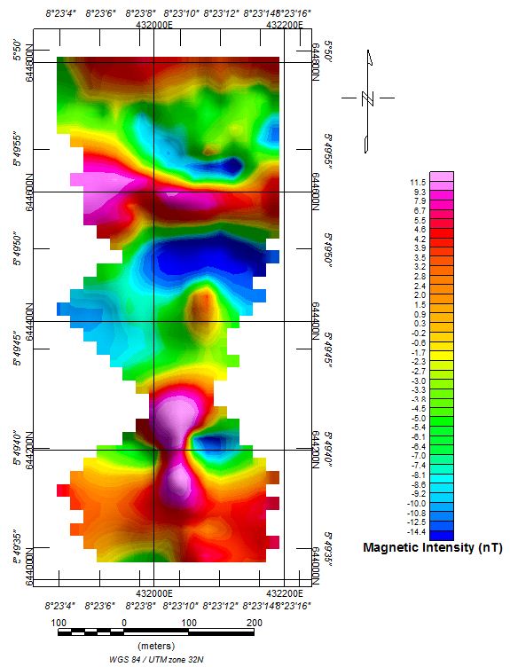
Figure 3.1: Magnetic Intensity Map of Iyamitet Obtained from Ground Magnetic Data.
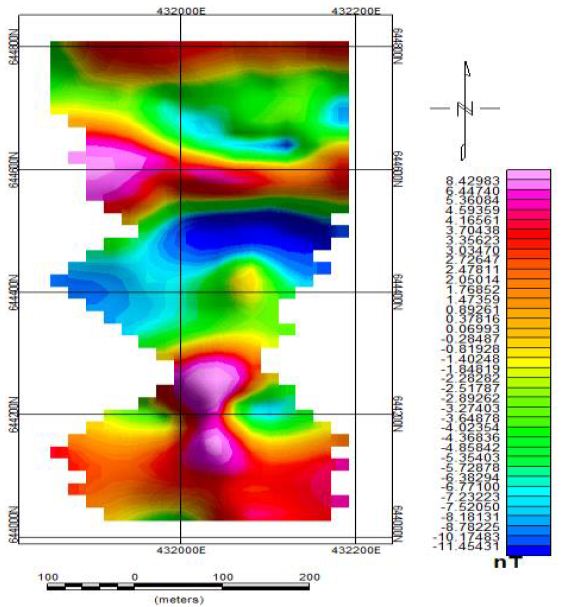
Figure 3.2: Ground Magnetic Intensity Map of Iyamitet (Upward Continued to 20 m.
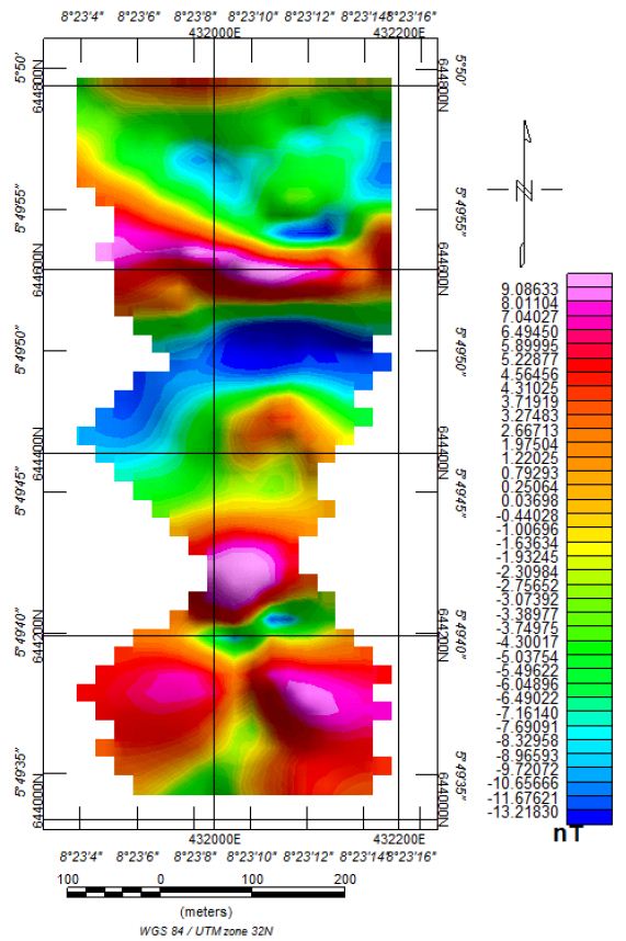
Figure 3.3: Reduction to the Equator Map of Iyamitet
Results
- Integrated geophysical interpretation revealed: A dominant NE–SW-trending structural corridor controlling mineralization.
- Low magnetic intensity zones coinciding with high pseudo-gravity anomalies.
- Conductive zones delineated by VLF-EM corresponding to fracture systems.
- Depth estimates indicating shallow (<10 m) to intermediate (~50 m) mineralized bodies.
- Analytical signal and Euler solutions confirmed structural controls on mineral emplacement (Figures 4.1-4.7).
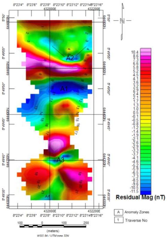
Figure 4.1: Residual Ground Magnetic Intensity Map of Iyamitet.
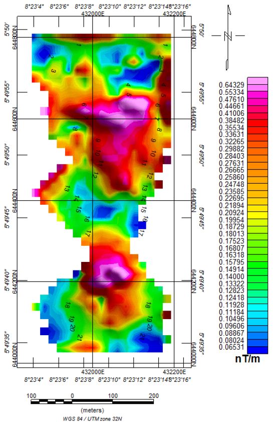
Figure 4.2: Analytical Signal Map of the Study Area.
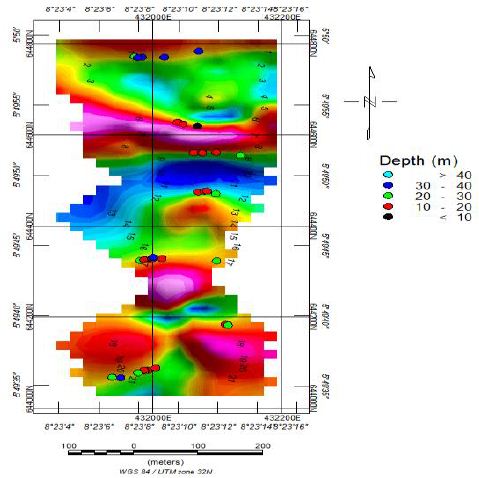
Figure 4.3: 3-D Euler Solution Map of Iyamitet (SI = 0).
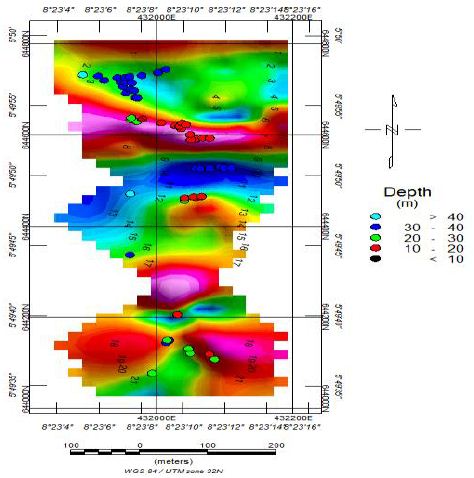
Figure 4.4: 3-D Euler Solution Map of Iyamitet (SI = 0.5).
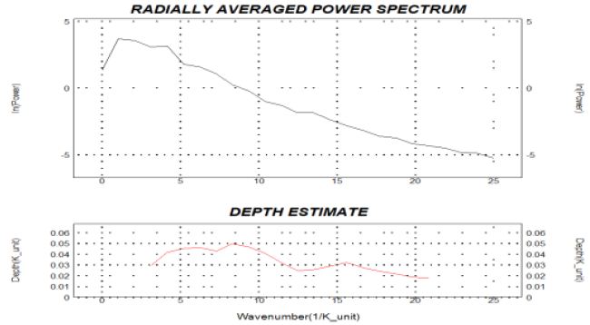
Figure 4.5: Radially Averaged Spectrum Map of Iyamitet.
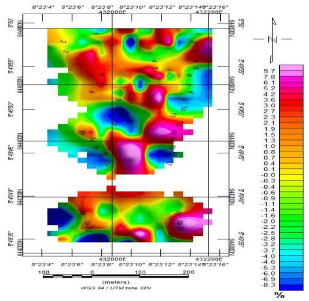
Figure 4.6: Raw Real Component Map of Iyamitet.
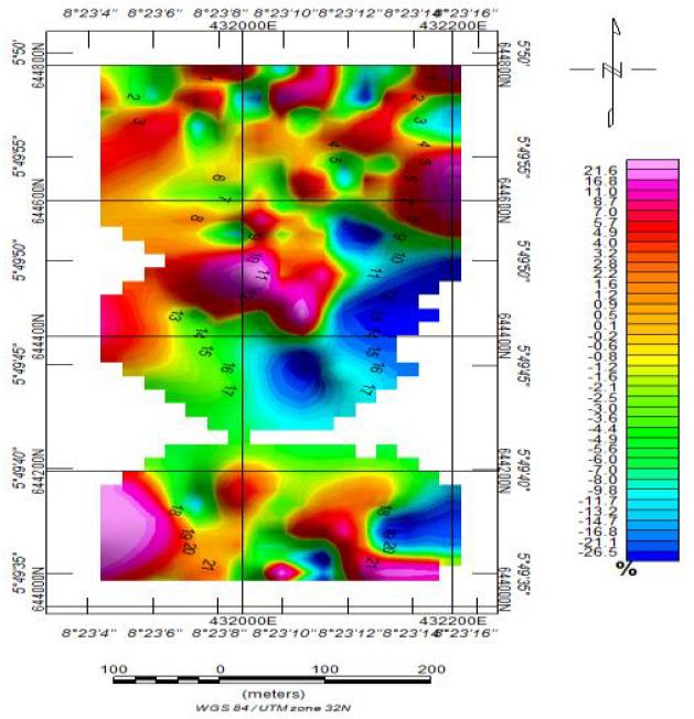
Figure 4.7: Q-Factor Map of Iyamitet Obtained from Filtering of the Raw Real Data.
Discussion
The VLF-EM and ground magnetic maps of the Iyamitet area reveal significant subsurface structural and lithological characteristics that strongly favour the occurrence of structurally controlled barite–galena mineralisation. The integration of the Residual Magnetic Intensity Map, Analytical Signal Map, Euler Depth Solutions, and Q-Factor filtering maps provides convincing evidence for fracture-controlled hydrothermal mineral deposition within the study area. The Residual Ground Magnetic Intensity Map (Figure 4.1) shows pronounced magnetic contrasts characterized by alternating zones of high and low magnetic intensities. The dominant low magnetic closures (blue to cyan colours) observed particularly within the central and northeastern portions of the study area are interpreted as zones of hydrothermal alteration, demagnetization, and structural weaknesses. These low magnetic signatures are typical of sulphide-bearing mineralized zones because galena (PbS) and barite (BaSO₄) are essentially non-magnetic minerals and are commonly associated with altered host rocks that have undergone destruction of magnetic minerals such as magnetite during hydrothermal fluid circulation. Conversely, the moderate to high magnetic anomalies (yellow, red, and purple zones) surrounding the low magnetic corridors likely represent relatively fresh basement rocks or ferruginized lithologies which acted as competent host rocks and structural traps for mineralizing fluids. The sharp magnetic gradients observed between magnetic highs and lows indicate lithological contacts and faulted boundaries that served as migration pathways for hydrothermal solutions responsible for barite–galena emplacement. The Analytical Signal Map (Figure 3.5) further enhances the delineation of structural contacts and subsurface discontinuities independent of magnetization direction. The strong analytical signal amplitudes trending predominantly NE–SW and NW–SE suggest the presence of deep-seated fracture systems and fault intersections. These structural trends are highly significant because barite–galena mineralisation within the Benue Trough and adjoining basement terrains of Nigeria is commonly controlled by fault systems, shear zones, and fracture networks. The analytical signal closures around the central part of the map indicate concentrated subsurface structural disturbances which may represent mineralized veins or hydrothermal conduits. The clustering of anomalies around these lineaments strongly suggests structurally localized sulphide mineralisation. The intersection zones of the lineaments are especially important because they usually provide enhanced permeability for ascending hydrothermal fluids and consequently form favourable sites for barite and galena deposition.
The 3-D Euler Solution Maps (Figures 4.3 and 4.4) provide depth estimations and geometric characterization of the causative bodies. The Euler solutions with Structural Index (SI = 0) are indicative of contact-type geological structures such as faults, lithological boundaries, and vein systems. The clustering of Euler depth solutions along elongated trends suggests the presence of continuous structural corridors. These corridors are interpreted as fracture-controlled mineralized zones favourable for epigenetic barite–galena deposition. Similarly, the Euler solutions with SI = 0.5 indicate dyke-like or vein-like bodies occurring at shallow to intermediate depths. The concentration of these solutions within the central and southern parts of the study area strongly supports the existence of vein-controlled mineralisation. Barite and galena deposits in Nigeria are commonly emplaced as hydrothermal veins along fault planes and fractures; therefore, the observed Euler signatures strongly favour this style of mineral occurrence. The depth estimates ranging approximately from near-surface to moderate depths further increase the economic significance of the mineralization because shallow hydrothermal sulphide systems are generally more accessible for exploration and possible exploitation. The Q-Factor Map (Figure 4.7), derived from filtering of the VLF-EM real component data, provides one of the strongest evidences for conductive mineralized structures within the area. The map reveals several conductive zones represented by anomalous closures and linear conductive trends. These conductive anomalies are interpreted as sulphide-rich fracture zones because galena exhibits relatively high electrical conductivity compared to surrounding country rocks. The conductive linear features identified on the Q-Factor map correspond spatially with the structural trends mapped from the magnetic interpretation. This correlation strongly validates the interpretation of interconnected fracture-controlled mineralized systems. The conductive anomalies labelled around the central and western portions of the study area are particularly significant because they coincide with zones of magnetic lows and Euler structural clustering.
Such coincidence between:
- conductive VLF-EM anomalies,
- magnetic discontinuities,
- analytical signal peaks,
- And a clustered Euler depth solution is a classical geophysical signature of structurally controlled hydrothermal sulphide mineralisation.
The VLF-EM response also suggests that the mineralized fractures are likely steeply dipping and laterally extensive. This interpretation is consistent with hydrothermal barite–galena veins commonly associated with tectonic reactivation and fluid migration along regional fractures. Geologically, the integrated geophysical signatures suggest that the Iyamitet area experienced intense tectonic deformation that created interconnected fracture systems which later became conduits for hydrothermal fluids rich in barium, lead, zinc, and associated sulphides. The hydrothermal fluids precipitated barite and galena within structurally weak zones, especially along lithologic contacts, fractures, and fault intersections.
The spatial association of:
- low magnetic anomalies,
- conductive VLF-EM zones,
- fracture-related Euler clusters,
- and analytical signal lineaments therefore strongly favours the presence of structurally controlled barite–galena mineralisation within the Iyamitet area. The integrated interpretation of the VLF-EM and aeromagnetic and ground geophysical datasets confirms that the Iyamitet area possesses favourable subsurface structural architecture and hydrothermal conditions for economically viable barite–galena mineral deposition (Figure 4.8).
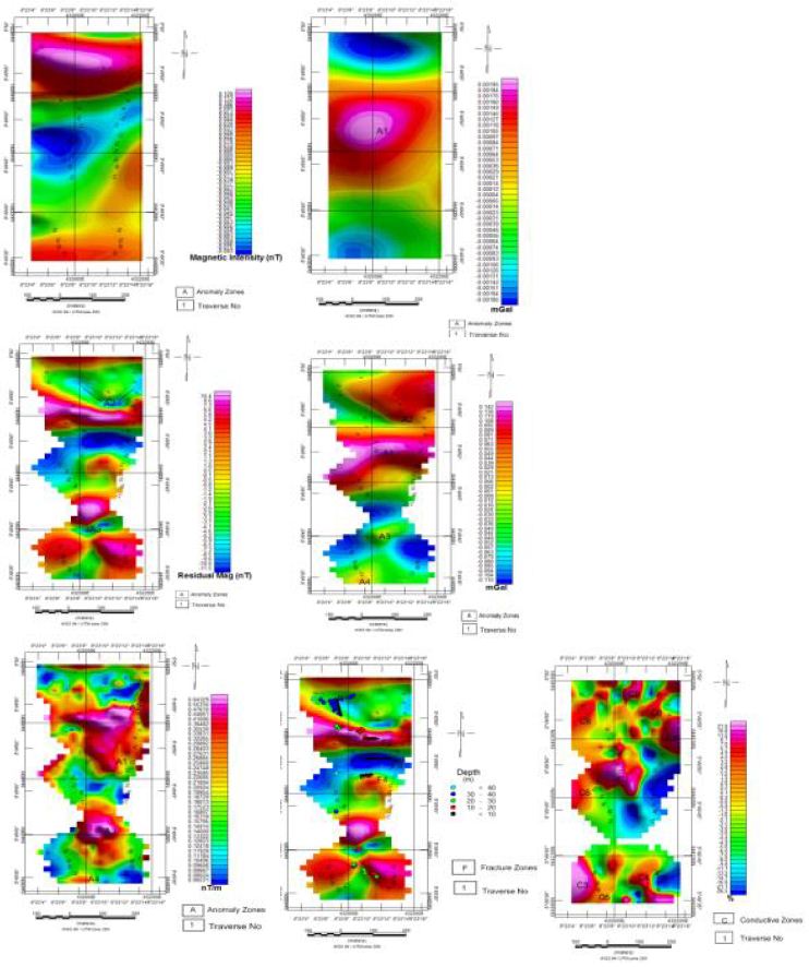
Figure 4.8(a-g): Maps Showing Synthesis of Results.
The synthesis maps (Figure 4.8 a–g) show the integrated interpretation of the geophysical datasets within the study area. Variations in colour patterns indicate contrasts in subsurface properties, structural features, and mineralisation potential. High-anomaly zones represented by red, pink, and purple colours suggest possible mineralised or conductive regions, while blue and green zones indicate relatively resistive formations.
The maps reveal structurally controlled anomalies associated with fractures, faults, and alteration zones that may have served as pathways for mineralising fluids. Concentrated and continuous anomalous zones observed in the central and lower sections are interpreted as favourable targets for mineralisation. Generally, the synthesis results indicate significant subsurface heterogeneity and delineate prospective zones suitable for further detailed exploration, trenching, and drilling activities [7-9] (Figure 5).
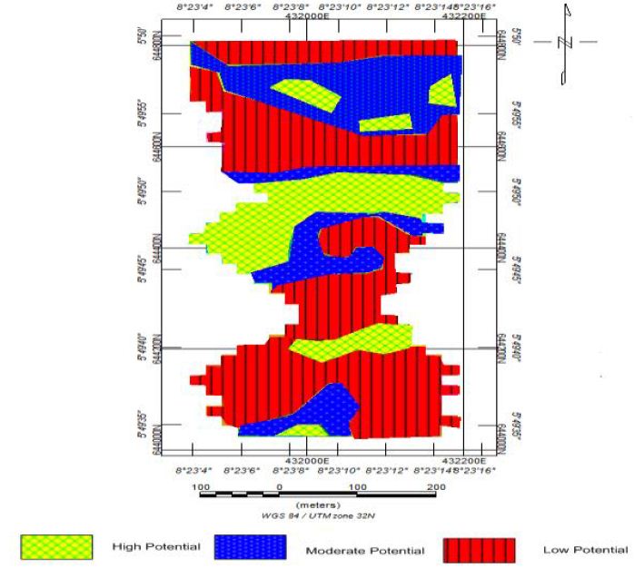
Figure 5: Mineralization Potential Zonation Map of Iyamitet.
Conclusions
The mineralisation potential zonation map of the Iyamitet area reveals well-defined anomalous zones characterized by structurally controlled conductive and resistive signatures favourable for Barite–Galena mineralisation. The distribution of the anomalous zones suggests hydrothermal fluid emplacement along fractures, faults, and lithological contacts within the subsurface. The moderate to high mineralisation potential zones identified on the map indicate significant concentration of sulphide-bearing minerals, particularly galena associated with barite veins. The continuity and spatial extent of the favourable zones further suggest that the Iyamitet area possesses appreciable economic potential for Barite–Galena deposit development. The integrated interpretation therefore confirms that the area is prospective for hydrothermal Pb–Zn–Barite mineralisation and justifies detailed exploration involving trenching, core drilling, geochemical sampling, and reserve estimation to delineate the ore body and evaluate its commercial viability.
Acknowledgement
The author acknowledges field support and geophysical data acquisition assistance from relevant technical teams, Contribution of late Mr Romanus E.J. to his blessed memory is well appreciated in this research work.
References
- Oladapo MI, Oladapo-Adeoye OO (2011) Geophysical Investigation of Barite Deposit in Tunga, Northeastern Nigeria. International Journal of the Physical Sciences 6: 4760-4774.
- Ezekwesili GE, Celestine OO, Chidozie IP (2012) Structural styles and economic potentials of some barite deposits in the Southern Benue Trough, Nigeria. Romanian Journal of Earth Sciences 86: 27-40.
- Obaje NG (2009) Geology and Mineral Resources of Nigeria, London. Springer Dordrecht. Pp 221.
- Akinde AS, Dikedi PN, Ogharandukun (2019) Adopting Geo-electric Approach in Mineral Characterisation of Iyamitet Settlement. Journal of Geology and Geophysics 8: 1-7.
- Akinde AS, Afuwai CG, Gata TB (2026b) Efficacy of Magnetotelluric Method in Delineating Structural Traps Hosting Groundwater Bodies. International Journal of Natural and Practical Sciences 8: 1-3.
- Oden MI, Okpamu TA, Amah EA (2012) Comparative analysis of fracture lineaments in oban and obudu areas, SE Journal of Geography and Geology. 4. ISSN 19169779. E-ISSN 1916-9787. Published by Canadian Center of Science and Education.
- Geosoft (2005) Quick start Tutorial and User guide applications (Electronic Version); Oasis Montaj data processing and analysis (DPA) system for Earth Science applications, Euro Technologies, 2007, Version.5.1.4, 242.
- Oyeniyi TO, Salami AA, Ojo SB (2016) Magnetic Surveying as an Aid to Geological Mapping: A Case Study from Obafemi Awolowo University Campus in Ile-Ife, Southwest Nigeria. Ife Journal of Science 18.
- Spector A, Grant FS (1970) Statistical Models for interpreting aeromagnetic data. Geophysics 35: 293-302.