Abstract
Quaternary crustal movement of the Japanese islands caused the rapid uplift of mountain ranges and the relative subsidence of coastal and inland basins. In particular, from the Early Pleistocene, there was rapid uplift of the major mountain ranges, and in coastal areas, fan-deltas caused the burial of land shelf slopes and fan expansion. As one example, this paper presents the depositional processes of the Ogasa Group, which consists of gravelly fan-delta deposits on the Pacific coast in central Japan. The Ogasa Group divided into the Soga, Osuga, Kasui and Fukuroi Formations in ascending order. The depositional ages of these formations are estimated to be 1.78–1.19 Ma (Soga Formation), 1.19–0.91 Ma (Osuga Formation), 0.91–0.77 Ma (Kasui Formation), and after 0.77 Ma (Fukuroi Formation). The depositional processes and paleogeographical changes of the Ogasa Group can be divided into four stages as follows. Stage A: during the depositional stage of the Soga Formation, sand and mud were deposited from the shoreface to the continental slope, and at the late of this stage, the northwestward submarine channel was buried by coarse-grained sediments from the Tenryu River. Stage B: during the depositional stage of the Osuga Formation, the formation of a large fan-delta by the Oi River from the northeast, which successively advanced to the southwest, expanding the fan and extending offshore. Therefore, an inner bay was formed on its northwestern side, and sand and gravel from the Tenryu River were deposited. Stage C: during the depositional stage of the Kasui Formation, a lake was formed by sandbars formed offshore duo to the transgression. Stage D: during the subsequent deposition of the Fukuroi Formation, the fan formed by the Tenryu and Oi Rivers was thought to have expanded to the south.
Keywords
Middle Pleistocene, Ogasa Group, Fan-delta, Akaishi Mountains, Oi River, Tenryu River
Introduction
In central Honshu, Japan, there was rapid uplift of the Akaishi Mountains and other major mountain ranges from the late Pleistocene (Calabrian), and the land area expanded due to the supply of gravelly sediments in the surrounding areas [1]. Based on detailed stratigraphic and chronostratigraphic data of the Pliocene to Pleistocene in the central Honshu area, Shiba [2,3] divided the stratigraphic processes into four stages, placing the late early Pleistocene to early middle Pleistocene (Calabrian to early Chibanian), when the entire area became terrestrial with large-scale uplift of the Akaishi Mountains and other mountain ranges, in the Stage 2. During this stage, the island arc underwent a general uplift, and the subsidence area of the inland basin expanded, while in the coastal areas, the fan- delta caused the burial and landwardization of the shelf slopes and the expansion of fan areas. The Ogasa Group [4] is distributed in the coastal area of the Pacific Ocean between the Tenryu and Oi Rivers in western Shizuoka Prefecture (Figure 1) and consists mainly of gravelly fan-delta deposits from the late Early to early Middle Pleistocene. The large amount of sand and gravel comprising the Ogasa Group is supplied by the Tenryu and Oi Rivers, which originate from the Akaishi Mountains in the northern part of the distribution area, and the fan-deltas were formed when the Akaishi Mountains began to uplift on a large-scale [5]. Therefore, clarifying the details of the stratigraphy of the Ogasa Group and its depositional processes will help to better characterise the Stage 2 [2,3] of the Quaternary crastal tectonics. Shiba et al. [6] established the stratigraphy and depositional age of the Ogasa Group and inferred the depositional process based on the reconstruction of the depositional environment and its changes. This paper introduces the depositional processes of the Ogasa Group based on that paper [6].
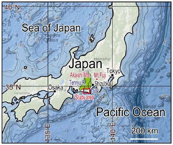
Figure 1: Location map showing the study area indicated by the red box. R, River; Mts, Mountains; Mt. Mountain.
Stratigraphic Overview of the Ogasa Group
The Ogasa Group is Pleistocene series, mainly in Kakegawa and Fukuroi cities, and is exposed northwest to southeast on the Iwatahara Plateau, Enden Hills, Kasui Hills, Ogasa Hills and Minamiyama Hills (Figure 2). Many stratigraphic and palaeontological studies [4,7,8] have been carried out on the Ogasa Group. However, the lithology of the Ogasa Group is composed of thick gravels interbedded with sand and mud beds, which repeat from the lower to the upper part of the Group many times. The Ogasa Group is distributed far apart on the Ogasa Hills and other Hills, with different lithologies on each Hills, it was difficult to correlate the stratigraphy between hills.
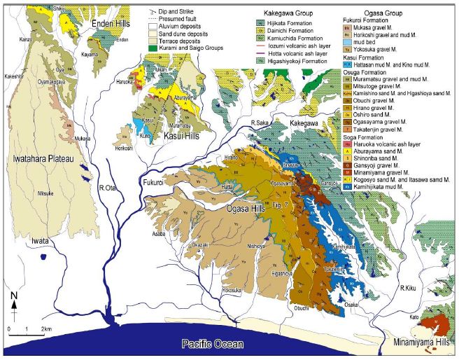
Figure 2: Geological map of the Ogasa Group. M., Member.
The Ogasa Group consists of fan-delta deposits, mainly gravels, and unconformably overlies the uppermost part of the Kakegawa Group, the Hijikata Formation. The Ogasa Group is subdivided into the Soga, Osuga, Kasui and Fukuroi Formations (Figure 3), northwest-southeast running, inclined 5–10 degree to the southwest. The Kakegawa Group is a marine formation consisting of sand, mud, alternating sand and mud, and gravel beds, and is mostly composed of submarine fan deposits such as turbidite, except for shallow-water shelf deposits of the transgressive period in the upper part of this Group. The strata of the Kakegawa Group strike northwest-southeast and dip 15–30 degree to the southwest.
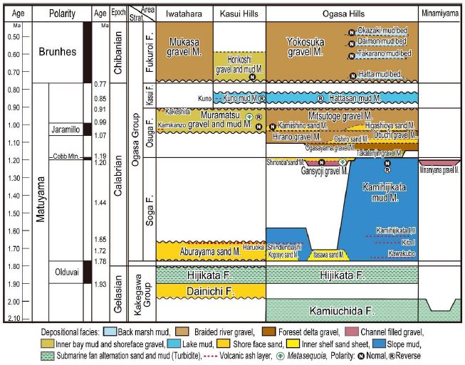
Figure 3: Stratigraphy and geological age of the Ogasa Group. F., Formation; M., Member; Strat., Stratigraphy. Cobb Mtn., Cobb Mountain. Wave line shows erosional surface.
The Soga Formation consists of the Aburayama sand Member in the Iwatahara Plateau, Enda Hills and Kasui Hills. In the Ogasa Hills, the Soga Formation consists of the Kogosho sand, Itasawa sand, Kamihijikata mud, Gansyoji gravel and Shinonba sand Members, while in the Minamiyama Hills, the Minamiyama gravel Member is distributed. The Osuga Formation is subdivided into the Takatenjin gravel, Ogasayama gravel, Oshiro sand, Hirano gravel, Obuchi gravel, Kamiishino sand, Higashioya sand and Mitsutoge gravel Membersin the Ogasa Hills. On the other hills, it consists of the Muramatsu gravel and mud Member. The Kasui Formation consists of the Kuno mud Member in the Kasui Hills and the Hattasan mud Member in the Ogasa Hills. The Fukuroi Formation consists of the Mukasa gravel Member in the Iwatahara Plateau, the Horikoshi gravel and mud Member in the Kasui Hills and the Yokosuka gravel Member on the Ogasa Hills.
Depositional Age of the Ogasa Group
The basement of the Ogasa Group is directly above the upper limit of the Olduvai Subchron [9], which corresponds to the Calabrian basement (approximately 1.8 Ma). Kameo [10] recognised the occurrence of the calcareous nannofossil Gephyrocapsa caribbeanica near the horizon of the Haruoka volcanic ash layer in the lower part of the Soga Formation at the eastern foot of the Ogasa Hills, and Gephyrocapsa oceanica slightly above the volcanic ash layer. According to Takayama et al. [11], the Haruoka volcanic ash layer was deposited at 1.72–1.65 Ma. Kameo [10] recognised the extinction of a large Gephyrocapsa genus in the uppermost horizon of the Soga Formation at the eastern foot of the Ogasa Hills, and assigned a base date of 1.2 Ma according to Takayama et al [11]. Ishida et al. [8] found normal magneticepoch in the uppermost part of the Soga Formation northwest of Takatenjin and in the basal part of the Gansyoji gravel Member. This is contrasted with the Cobb Mountain Subchron when combined with data from Kameo [10]. Therefore, the Soga Formation at the eastern foot of the Ogasa Hills is estimated to have been deposited between 1.78 and 1.19 Ma. In contrast, the Soga Formation of the Kasui Hills is not distributed strata in the Soga Formation above 1.65 Ma because its uppermost stratigraphic horizon is the Haruoka volcanic ash layer. The Soga Formation was deposited between 1.78 and 1.19 Ma, which means that the Osuga Formation was deposited after 1.19 Ma. Ishida et al. [8] recognised that the Kamiishino sand Member and the lower part of the Muramatsu gravel and mud Member of the Kasui Hills were deposited during the normal magnetic epoch, and compared their horizons to the Jaramillo Subchron. The Jaramillo Subchron is 1.07–0.99 Ma according to Gibbard and Head [12]. Therefore, in the Kasui Hills, the Muramatsu gravel and mud Member may have been deposited after 1.07 Ma, the base of the Jaramillo Subchron, while the upper part of this Member is reverse magnetic epoch, suggesting that it was deposited after 0.99 Ma. The upper part of the Osuga Formation in the Iwatahara Plateau is intercalated with the Kamikanzo volcanic ash layer. This ash layer is contrasted with the U8 volcanic ash layer of the Umegase Formation of the Kazusa Group, whose eruption age is estimated to be 0.92–0.91 Ma (MIS 23–24) according to Suzuki et al. [13].
The Kasui Formation of the Kasui Hills is intercalated with the Kunovolcanic ash layer, which is correlate to the Azuki volcanic ash layer, which is intercalated with the Ma 3 Member of the Osaka Group; Satoguchi and Nagahashi [14] estimated the age of this ash layer to be about 0.85 Ma. The Kasui Formation of the Ogasa and Kasui Hills was deposited in the reverse magnetic epoch [8], which corresponds to the horizon between the Jaramillo Subchron and the Brunhes Chron. The Kasui Formation is considered to have been deposited between 0.91–0.77 Ma based on the absence of Metasequoia and the inferred age of the lower Osuga Formation.
According to Ishida et al. [8], the four mud beds interbedded near the base of the Fukuroi Formation (the Yokosuka gravel Member) in the Ogasa Hills and the mud beds of the Horikoshi gravel and mud Member in the Kasui Hills are all normal magnetic epoch. This suggests that the base of the Fukuroi Formation was deposited after 0.77 Ma at the Brunhes-Matuyama Chron boundary, i.e. the base of Chibanian. The age of the uppermost part of the Ogasa Group cannot be specifically estimated because the uppermost horizon of the Ogasa Group could not be determined in this study. However, if the Ogasa Group is contrasted with the Osaka and Kazusa Groups, the uppermost part of the Ogasa Group is probably dated at around 0.4 Ma, which is considered to be the upper limit of both groups.
Depositional Environment of the Ogasa Group
The Soga Formation, the lowermost member of the Ogasa Group, is distributed in the Iwatahara-Kasui area by the Aburayama sand Member, which was deposited in the upper to lower shoreface. On the Ogasa Hills, on the other hand, the Kamihijikata mud Member was deposited on the continental slope from the outer continental shelf, while the Kogosho sand and the Itasawa sand Members were deposited on the inner shelf during the storm. The submarine channel deposits, the Gansyoji gravel and the Minamiyama gravel Members, were deposited above them, and the Shinonba sand Member, which have been deposited on the upper shoreface to inner shelf, accumulated. The sands of the Soga Formation include biotite and the gravels contain quartz porphyry and diorite, all of which are presumed to have been supplied by the Tenryu River system. In the Iwatahara-Kasui area, the Osuga Formation consists of the Muramatsu gravel and mud Formation, which is presumed to have been formed by several repetitions of the depositional environment of the inner bay or lagoon and upper shoreface or the diverging sandbar near the river mouth. From the sand and gravel of this member, it is assumed that these sediments were supplied by the Tenryu River system. On the other hand, the Osuga Formation at the eastern foot of the Ogasa Hills consists of the Takatenjin gravel Member, which was deposited near the mouth of the river from a sandbar on the river margin, followed by large-scale fan-delta front gravels (the Ogasayama gravel and Obuchi gravel Members) and fan braided river deposits (the Hirano gravel and Mitsutoge gravel Members). They consist of delta to fan deposits and are thought to have buried continental slopes. The absence of Tenryu River derived elements in the gravels of the Takatenjin gravel Member suggests that the sediments were supplied from the Oi River system and that the fan-delta of the Oi River system was first formed in the Ogasa Hills area during the Osuga Formation depositional period. The Ogasayama gravel Member is thought to have been supplied by the Oi River system, and this fan-delta expanded by advancing from north-east to south-west in the direction of the tilted stratification. The Oshiro sand Member overlying the Ogasayama gravel Member is thought to have been deposited on the upper shoreface, and the Hirano gravel Member of fan deposits and the Obuchi gravel Member deposited on the fan-delta front to the south of it were deposited above it. These gravel beds are also composed of sediments from the Oi River system, and this horizontal and vertical succession of lithologies corresponds to the progressive delta of Reading and Collinson [15], suggesting that the fan-delta developed in a more southerly offshore area at this time. The fan-delta is thought to have developed in a more southerly offshore extent at this period.
The Hiranogravel and the Obuchi gravel Members are overlain by the Kamiishino sand Member, the Higashioyasand and the Mitsutogegavel Members. These Members are deposits of lower shoreface, lower shoreface to backshore and fan, respectively. The presence of the Kamiishino sand and the Higashioya sand Members suggests that the transgression occurred prior to the deposition of these Members. The subsequent relative sea-level stagnation or falling of the sea-level formed the Kamiishino sand and Higashioyasand Members, and the fan sediments, the Mitsutoge gravel Member, was deposited above them, suggesting that an advancing fan-delta developed further to the south, extending the fan. The deposition of the Osuga Formation in the Ogasa Hills is thought to have completely buried and terrestrialised the continental slopes. In the sediments of the Osuga Formation, no sediments such as biotite sands or quartz porphyry gravels suggest that they were supplied from the Tenryu River system, except for the Kamiishino sand Member, and these sediments are thought to have been supplied from the Oi River system. The Kuno mud Member distributed in the Kasui Hills are presumed to have been deposited on the bottom of a freshwater lake with little influence from waves, based on the mud beds with well-developed laminae and shell fossils. The Hattasanmud Member in the Ogasa Hills is also presumed to have been deposited on a water bed based on its lithology. The Kasui Formation is considered to have been deposited during a transgressive period, because the depositional period of the Kasui Formation correlates with that of the Ma 3 Member, a transgressive deposit of the Osaka Group, and the mud beds of the Kasui Formation are widely distributed continuously from the Ogasa Hills to the Kasui Hills. Regarding the depositional environment of the Fukuroi Formation, the Mukasa gravel Member of the Iwatahara Plateau and the Yokosuka gravel Member of the Ogasa Hills are similar to the braided river depositional facies of Miall [16] and are considered braided river deposits on two different large fans. The Horikoshi gravel and mud Member of the Kasui Hills has a recurring environment of lake mud deposition based on the freshwater shell fossils produced, and a gravel layer near the river mouth. The Fukuroi Formation consists of similar fan deposits on the Iwatahara Plateau and Ogasa Hills, while the Kasui Hills are thought to be lake deposits derived from the Kasui Formation. The gravel beds on the Iwatahara Plateau and Kasui Hills contain quartz porphyry, which was supplied by the Tenryu River system, whereas the gravel beds on the Ogasa Hills lack such elements, suggesting that they were supplied by the Oi River system.
Depositional Processes and Palaeogeography
The Ogasa Group consists mainly of coarse-grained sediments formed ravelly fan-delta that started in Calabrian, which was formed when the Akaishi Mountains began to uplift on a large-scale and the Tenryu River and Oi River became the supply rivers of coarse-grained sediments [5]. According to Moriyama and Mitsuno [17], the Ina-Akaishi tectonic crastal movement, which uplifted a mountain range with a specific height of 2,500 m from Ina Valley to the Akaishi Mountains, started after about 1.8 Ma in the early Pleistocene. Suganuma et al. [18] suggest that full-scale uplift of the Akaishi Mountains began between 1.4 and 1.0 Ma, based on the contrast of widespread volcanic ash layers interbedded in fan deposits in the Ina Basin. In this study area, it is estimated that after about 1.8 Ma in the early Pleistocene after the deposition of the Kakegawa Group, the area was generally uplifted, the Iwatahara-Kasui area became a land area, the north-eastern to eastern foot of the Ogasa Hills area became shallow water and a fan-delta was formed between the mouth of the Tenryu River system to the coast. During the late depositional stage of the Soga Formation at 1.2 Ma, a submarine channel-filled gravel bed was formed at the northeastern foot of the Ogasa Hills from the Tenryu River system, and a full-scale fan-delta of coarse-grained sediment was formed in the eastern Ogasa Hills during the depositional stage of the Osuga Formation that started after 1.19 Ma, receiving gravel supply from the Oi River system on its northeastern side. This period roughly coincides with the start of the full-scale, rapid uplift of the Akaishi Mountainsrange. Based on the depositional ages and depositional environments of the various Formations of the Ogasa Group described so far, the depositional processes and palaeogeography of the Group are shown in the following four stages, A to D (Figure4).
Stage A (The Soga Formation: 1.78–1.19 Ma)
In the Iwatahara-Kasui area to the Ogasa Hills area facing the Pacific Ocean, there was a sea area where the continental slope spread offshore from the shoreface during the Soga Formation depositional period, and there was a fan-delta of the Tenryu River system and a coast continuous with it (Figure 4A). At the end of this period, at 1.2 Ma, there was an inflow of coarse-grained sediments from the Tenryu River system from the northwest direction, resulting in the formation of submarine channels and their burial (Figure 4A(a)).
Stage B (The Osuga Formation: 1.19–0.91 Ma)
Two depositional areas, the Ogasa Hills area and the nearby Iwatahara-Kasui area, resulted in contrastingly different depositional environments: fan-deltas and inner bays respectively. The formation of a large fan-delta of the Oi River, which juts offshore into the Ogasa Hills area, has resulted in the development of different depositional environments in the two neighbouring east-west areas. An inner bay or lagoon was formed in the Iwatahara-Kasui area from 1.07 Ma onwards (Figure 4B). In the Ogasa Hills area, a large fan-delta was formed at the beginning of the Osuga Formation depositional stage by the Oi River system flowing into the Takatenjin area (Figure 4B(a)), followed by the Oi River system flowing in from the northeast side of the Kakegawa. Subsequently, the fan-delta progressively advanced to the southwest, fan expanding to offshore (Figure 4B(b)). An inner bay or lagoon (Figure 4B(c)) was formed in the Iwatahara-Kasui area on its northwestern side, and mud, sand and gravel beds were deposited in the inner bay from the Tenryu River system. During this period, a large fan-delta is assumed to have formed in the lower reaches of the present-day Tenryu River (Figure 4B(d)), and the Iwatahara-Kasui area is estimated to have been a deep inner bay environment due to fan-deltas extending on both east and west sides.
Stage C (The Kasui Formation: 0.91–0.77 Ma)
The fan area extending offshore from the Iwatahara-Kasui and Ogasa areas was submerged by the transgression, but the inner part of the fan area was closed by offshore sandbars formed by wave erosion of the fan area, forming a freshwater lake. The lake then expanded to the north due to the transgression (Figure 4C).
Stage D (Fukuroi Formation: after 0.77 Ma)
Large fan-deltas were formed by the Tenryu River and the Oi River in both the Iwatahara Plateau and the Ogasa Hills, respectively, and fan areas spread out. Each of them moved southwards and buried the offshore continental slopes. However, a lake remained in the southern part of the Kasui Hills in this early stage (Figure 4D).
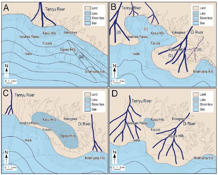
Figure 4: Depositional processes and paleogeographic evolution of the Ogasa Group. The dotted shapes in the background represent the current topography, and the solid lines indicate isobaths at 100 m intervals. The dotted areas represent depths shallower than 100 m. A, The depositional stage of the Soga Formation (1.78–1.19 Ma), (a) The Gansyoji submarine channel; B, The depositional stage of the Osuga Formation (1.19–0.91 Ma), (a) The Takatenjin delta plain, (b) Fan-delta of the Oi River during the depositional stage of the Ogasayama gravel to the Mitsutoge gravel Members, (c) The inner bay between the Oi and Tenryu River fans, (d) Fan-delta of the Tenryu River; C, During the depositional stage of the Kasui Formation (0.91–0.77 Ma), a lake appeared on the Ogasa and Kasui Hills; D, The depositional stage of the Fukuroi Formation (0.77 Ma~), The fans of the Tenryu and Oi Rivers developed to the south again.
Acknowledgment
The author would like to thank Ms. Kate Mariana, Geology, Managing Editor of Earth & Marine Sciences, for the publication of this paper.
References
- Matsuda T, Kinugasa Y (1988) Quaternary tectonic movements – the characteristics and the related problems on the Japanese Islands. The Quaternary Researh 26: 251-254.
- Shiba M (2021) Quaternary tectono-sedimentary history of the central Honshu area, Japanese Islands. New Concepts in Global Tectonics Journal 12: 105-131.
- Shiba M (2024) Characteristics of crustal uplift since the Pliocene in central Honshu, Japan, and sea level rise. Earth Science (Chikyu Kagaku) 75: 37-55.
- Makiyama J, Sakamoto T (1957) Explanatory text and the geological map of Japan, scale 1: 50000, Mitsuke and Kakezuka. Geological Suvery of Japan.
- Shiba M (2017) Formation of Suruga Bay, Large-scale uplift of arc and sea level rise. Tokai Univ. Press, Hiratsuka. Pg: 406.
- Shiba M, Nakamoto Y, Ohsako T, Nagahashi Y, Yokoyama K (2024) Stratigraphy, age and depositional process of the Ogasa Group, Pleistocene series in the western part of Shizuoka Prefecture, Japan. Earth Science (Chikyu Kagaku) 78: 159-178.
- Kuroda K (1975) Plant remains from the Pleistocene Ogasa Group, Shizuoka Prefecture, Japan. Jour Geol Soc Japan 81: 721-735.
- Ishida S, Makinouchi T, Nishimura A, Takemura K, Danhara T, et al. (1980) Middle Pleistocene of Kakegawa district, central Japan. The Quaternary Research 19: 133-147.
- Yoshida K, Niitsuma M (1976) Magneto-stratigraphy in the Kakegawa district. Pg: 54-59. In: Tsuchi R (ed), Neogene geology of the Kakegawa district 1-CPNS, Guidebook for Excursion 3, Kakegawa district.
- Kameo K (1998) Upper Neogene and Quaternary stratigraphy in the Kakegawa district besed on the calcareous nannofossil datum plain – With reference to the stratigraphic position of the Tamari Formation. Jour Geol Soc 104: 672-686.
- Takayama T, Sato T, Kameo K, Goto T (1995) Quaternary Coccolith Biostratigraphy and the Age of the Pliocene/Pleistocene Boundary. The Quaternary Research 34: 157-170.
- Gibbard PL, Head MJ (2020) The Quaternary Period. Pg: 1217-1255, In: Gradstein FM, Ogg JG, Schmitz MD, Ogg GM (eds), Geologic Time Scale 2020, Elsevier, Amsterdam, Oxford, Cambridge, Pg: 1357.
- Suzuki T, MurataM, Mizuno K, Ishihara T (2017) Sequence of Early Pleistocene Shirakawa ignimbrites and their identifications in distal areas in Northeast Japan. Quat Int 456: 195-209.
- Satoguchi Y, Nagahashi Y (2012) Tephrostratigraphy of the Pliocene to Middle Pleistocene series in Honshu and Kyushu islands, Japan. Island Arc 21: 149-169.
- Reading HG, Collinson JD (1996) Clastic coasts. Pg: 156-231, In: Reading HG (ed), Sedimentary Environments: Processes, Facies and Stratigraphy, Blackwell Publishing, Victoria, Australia, Pg: 688.
- Miall AD (1977) A review of the braided-river depositional environment. Earth-Science Reviews 13: 1-62.
- Moriyama A, Mitsuno K (1989) The uplifting of the Kiso and Akaishi mountain ranges deduced from the sedimentary, Deposits and the Ryuto surface in the southern Ina Valley, central Japan. Geographical Review Japan 62A-10: 691-707.
- Suganuma Y, Suzuki T, Yamazaki H, Kikuchi T (2003) Chrono-stratigraphy of the Ina Group, central Japan, based on correlation of volcanic ash layers with Pleistocene widespread tephras. The Quaternary Research 42: 321-334.